File:Perspective view of truss span, looking NE. - Pennsylvania Railroad, West Brownsville Junction Bridge, Spanning Monongahela River, north of U.S. Route 40 Bridge, West Brownsville, HAER PA,63-BROVW,1-2.tif
Vai alla navigazione
Vai alla ricerca

Dimensioni di questa anteprima JPG per questo file TIF: 800 × 571 pixel. Altre risoluzioni: 320 × 228 pixel | 640 × 457 pixel | 1 024 × 731 pixel | 1 280 × 914 pixel | 2 560 × 1 827 pixel | 5 000 × 3 569 pixel.
File originale (5 000 × 3 569 pixel, dimensione del file: 17,02 MB, tipo MIME: image/tiff)
| Questo file e la sua pagina di descrizione (discussione · modifica) si trovano su Wikimedia Commons (?) |
| Perspective view of truss span, looking NE. - Pennsylvania Railroad, West Brownsville Junction Bridge, Spanning Monongahela River, north of U.S. Route 40 Bridge, West Brownsville, Washington County, PA | ||||
|---|---|---|---|---|
| Fotografo |
Lowe, Jet, creator |
|||
| Titolo |
Perspective view of truss span, looking NE. - Pennsylvania Railroad, West Brownsville Junction Bridge, Spanning Monongahela River, north of U.S. Route 40 Bridge, West Brownsville, Washington County, PA |
|||
| Descrizione |
Leonard, H R; Pennsylvania Steel Company; Lucius Engineering Company; Pennsylvania Railroad; Consolidated Rail Corporation (Conrail); Norfolk Southern Railroad; DeLony, Eric N, project manager; Pennsylvania Historical and Museum Commission, sponsor; Consolidated Rail Corporation (Conrail), sponsor; Spivey, Justin M, historian; Lowe, Jet, photographer |
|||
| Luogo rappresentato | Pennsylvania; Washington County; West Brownsville | |||
| Data | 1999 | |||
| Dimensioni | 5 x 7 in. | |||
| Ubicazione attuale |
Library of Congress Prints and Photographs Division Washington, D.C. 20540 USA http://hdl.loc.gov/loc.pnp/pp.print |
|||
| Numero d'inventario |
HAER PA,63-BROVW,1-2 |
|||
| Attribuzione |
|
|||
| Note |
|
|||
| Fonte | https://www.loc.gov/pictures/item/pa3769.photos.362296p | |||
| Licenza (Riusare questo file) |
|
|||

Cronologia del file
Fare clic su un gruppo data/ora per vedere il file come si presentava nel momento indicato.
| Data/Ora | Miniatura | Dimensioni | Utente | Commento | |
|---|---|---|---|---|---|
| attuale | 07:59, 1 ago 2014 | 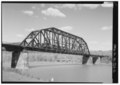 | 5 000 × 3 569 (17,02 MB) | Fæ | GWToolset: Creating mediafile for Fæ. HABS 31 July 2014 (3000:3200) |
Pagine che usano questo file
La seguente pagina usa questo file:
Utilizzo globale del file
Anche i seguenti wiki usano questo file:
- Usato nelle seguenti pagine di ceb.wikipedia.org:
- Usato nelle seguenti pagine di ce.wikipedia.org:
- Usato nelle seguenti pagine di cy.wikipedia.org:
- Usato nelle seguenti pagine di en.wikipedia.org:
- Usato nelle seguenti pagine di es.wikipedia.org:
- Usato nelle seguenti pagine di eu.wikipedia.org:
- Usato nelle seguenti pagine di fr.wikipedia.org:
- Usato nelle seguenti pagine di ht.wikipedia.org:
- Usato nelle seguenti pagine di lld.wikipedia.org:
- Usato nelle seguenti pagine di pt.wikipedia.org:
- Usato nelle seguenti pagine di sr.wikipedia.org:
- Usato nelle seguenti pagine di tt.wikipedia.org:
- Usato nelle seguenti pagine di uk.wikipedia.org:
- Usato nelle seguenti pagine di uz.wikipedia.org:
- Usato nelle seguenti pagine di vi.wikipedia.org:
- Usato nelle seguenti pagine di www.wikidata.org:
- Usato nelle seguenti pagine di zh-min-nan.wikipedia.org: