File:Overview of bridge; south side; view to north. - Rosebud Creek Bridge, Spanning Rosebud Creek at Secondary Highway 446, Rosebud, Rosebud County, MT HAER MT-118-2.tif
Vai alla navigazione
Vai alla ricerca

Dimensioni di questa anteprima JPG per questo file TIF: 745 × 600 pixel. Altre risoluzioni: 298 × 240 pixel | 596 × 480 pixel | 954 × 768 pixel | 1 272 × 1 024 pixel | 2 544 × 2 048 pixel | 5 614 × 4 519 pixel.
File originale (5 614 × 4 519 pixel, dimensione del file: 24,2 MB, tipo MIME: image/tiff)
| Questo file e la sua pagina di descrizione (discussione · modifica) si trovano su Wikimedia Commons (?) |
Dettagli
| Overview of bridge; south side; view to north. - Rosebud Creek Bridge, Spanning Rosebud Creek at Secondary Highway 446, Rosebud, Rosebud County, MT | ||||
|---|---|---|---|---|
| Fotografo |
Hager, Kristi, creator |
|||
| Titolo |
Overview of bridge; south side; view to north. - Rosebud Creek Bridge, Spanning Rosebud Creek at Secondary Highway 446, Rosebud, Rosebud County, MT |
|||
| Luogo rappresentato | Montana; Rosebud County; Rosebud | |||
| Data | 2004 | |||
| Dimensioni | 4 x 5 in. | |||
| Ubicazione attuale |
Library of Congress Prints and Photographs Division Washington, D.C. 20540 USA http://hdl.loc.gov/loc.pnp/pp.print |
|||
| Numero d'inventario |
HAER MT-118-2 |
|||
| Attribuzione |
|
|||
| Fonte | https://www.loc.gov/pictures/item/mt0439.photos.217943p | |||
| Licenza (Riusare questo file) |
|
|||

Cronologia del file
Fare clic su un gruppo data/ora per vedere il file come si presentava nel momento indicato.
| Data/Ora | Miniatura | Dimensioni | Utente | Commento | |
|---|---|---|---|---|---|
| attuale | 22:27, 28 lug 2014 | 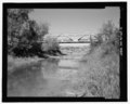 | 5 614 × 4 519 (24,2 MB) | Fæ | GWToolset: Creating mediafile for Fæ. HABS 24 July 2014 (2001:2300) |
Pagine che usano questo file
La seguente pagina usa questo file:
Utilizzo globale del file
Anche i seguenti wiki usano questo file:
- Usato nelle seguenti pagine di arz.wikipedia.org:
- Usato nelle seguenti pagine di ceb.wikipedia.org:
- Usato nelle seguenti pagine di de.wikipedia.org:
- Usato nelle seguenti pagine di en.wikipedia.org:
- Usato nelle seguenti pagine di www.wikidata.org: