File:RamblesMap.png
Vai alla navigazione
Vai alla ricerca
Non sono disponibili versioni a risoluzione più elevata.
RamblesMap.png (597 × 538 pixel, dimensione del file: 58 KB, tipo MIME: image/png)
| Questo file e la sua pagina di descrizione (discussione · modifica) si trovano su Wikimedia Commons (?) |
Dettagli
| Descrizione |
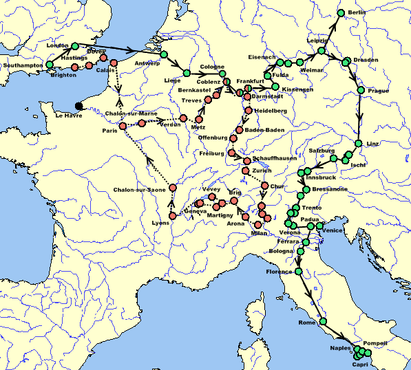
English: Map of Mary Shelley and her son Percy Florence Shelley's travels in 1840 and 1842–1843, taken from The Novels and Selected Works of Mary Shelley. Vol. 8. Ed. Jeanne Moskal. London: William Pickering, 1996, pg. 58–59. The red dots and dotted line indicate the 1840 trip; the green dots and solid line indicate the 1842–43 trip; dual-colored dots indicate places visited on both trips; black dots indicate places not visited but helpful for the reader. |
| Data | |
| Fonte | Own work by Awadewit, made with Online Map Creation |
| Autore | Awadewit |
| Altre versioni | Opere derivate da questo file: RamblesMap-es.JPG |
Licenza
Io, detentore del copyright su quest'opera, dichiaro di pubblicarla con le seguenti licenze:
Questo file è disponibile in base alla licenza Creative Commons Attribuzione-Condividi allo stesso modo 3.0 Unported
- Tu sei libero:
- di condividere – di copiare, distribuire e trasmettere quest'opera
- di modificare – di adattare l'opera
- Alle seguenti condizioni:
- attribuzione – Devi fornire i crediti appropriati, un collegamento alla licenza e indicare se sono state apportate modifiche. Puoi farlo in qualsiasi modo ragionevole, ma non in alcun modo che suggerisca che il licenziante approvi te o il tuo uso.
- condividi allo stesso modo – Se remixi, trasformi o sviluppi il materiale, devi distribuire i tuoi contributi in base alla stessa licenza o compatibile all'originale.

|
È permesso copiare, distribuire e/o modificare questo documento in base ai termini della GNU Free Documentation License, Versione 1.2 o successive pubblicata dalla Free Software Foundation; senza alcuna sezione non modificabile, senza testo di copertina e senza testo di quarta di copertina. Una copia della licenza è inclusa nella sezione intitolata Testo della GNU Free Documentation License. |
Puoi scegliere la licenza che preferisci.
Cronologia del file
Fare clic su un gruppo data/ora per vedere il file come si presentava nel momento indicato.
| Data/Ora | Miniatura | Dimensioni | Utente | Commento | |
|---|---|---|---|---|---|
| attuale | 07:47, 16 dic 2008 | | 597 × 538 (58 KB) | Awadewit | adding arrows |
| 07:17, 10 nov 2008 |  | 597 × 538 (56 KB) | Awadewit | adding arrows | |
| 17:02, 6 ago 2008 |  | 597 × 538 (37 KB) | Ruhrfisch | Awadewit's map, I just fixed the color of the seas. | |
| 16:13, 6 ago 2008 |  | 597 × 538 (37 KB) | Awadewit | {{Information |Description={{en|1=Map of Mary Shelley and her son Percy Florence Shelley's travels in 1840 and 1840-1840, taken from ''The Novels and Selected Works of Mary Shelley''. Vol. 8. Ed. Jeanne Moskal. London: William Pickering, 1996, pg. 58-59. |
Pagine che usano questo file
La seguente pagina usa questo file:
Utilizzo globale del file
Anche i seguenti wiki usano questo file:
- Usato nelle seguenti pagine di de.wikipedia.org: