File:NorthamptonshireWellingborough.png
Vai alla navigazione
Vai alla ricerca
Non sono disponibili versioni a risoluzione più elevata.
NorthamptonshireWellingborough.png (200 × 222 pixel, dimensione del file: 14 KB, tipo MIME: image/png)
| Questo file e la sua pagina di descrizione (discussione · modifica) si trovano su Wikimedia Commons (?) |
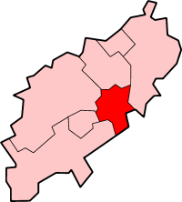
Wellingborough in Northamptonshire
Created by en:User:Morwen

|
È permesso copiare, distribuire e/o modificare questo documento in base ai termini della GNU Free Documentation License, Versione 1.2 o successive pubblicata dalla Free Software Foundation; senza alcuna sezione non modificabile, senza testo di copertina e senza testo di quarta di copertina. Una copia della licenza è inclusa nella sezione intitolata Testo della GNU Free Documentation License. |
| Questo file è disponibile in base alla licenza Creative Commons Attribuzione-Condividi allo stesso modo 3.0 Unported | ||
| ||
| Questo tag di copyright è stato aggiunto nell'ambito dell'aggiornamento della licenza dei progetti Wikimedia. |
Cronologia del file
Fare clic su un gruppo data/ora per vedere il file come si presentava nel momento indicato.
| Data/Ora | Miniatura | Dimensioni | Utente | Commento | |
|---|---|---|---|---|---|
| attuale | 23:05, 24 mag 2006 | | 200 × 222 (14 KB) | Nichtbesserwisser | Wellingborough in Northamptonshire Created by en:User:Morwen {{GFDL}} Category:Maps of districts in East Midlands |
Pagine che usano questo file
La seguente pagina usa questo file:
Utilizzo globale del file
Anche i seguenti wiki usano questo file:
- Usato nelle seguenti pagine di bg.wikipedia.org:
- Usato nelle seguenti pagine di de.wikipedia.org:
- Usato nelle seguenti pagine di en.wikipedia.org:
- Sywell Aerodrome
- Sywell
- Wellingborough
- Borough of Wellingborough
- Wollaston, Northamptonshire
- Grendon, Northamptonshire
- Wellingborough School
- Easton Maudit
- Wilby, Northamptonshire
- Isham
- Wellingborough (UK Parliament constituency)
- Mears Ashby
- Finedon
- Wellingborough railway station
- Ecton, Northamptonshire
- Great Doddington
- Strixton
- A509 road
- Earls Barton
- Bozeat
- Wellingborough Whitworth F.C.
- Wellingborough Town F.C.
- Irchester
- Redhill Grange
- Orlingbury
- Great Harrowden
- Little Harrowden
- Tresham College of Further and Higher Education
- The Castle Theatre, Wellingborough
- Hardwick, Northamptonshire
- Template:BC Wellingborough
- Usato nelle seguenti pagine di fa.wikipedia.org:
- Usato nelle seguenti pagine di nl.wikipedia.org:
- Usato nelle seguenti pagine di no.wikipedia.org:
- Usato nelle seguenti pagine di ro.wikipedia.org: