File:Livingston-Island-Map-2010-15.png
Vai alla navigazione
Vai alla ricerca
Dimensioni di questa anteprima: 799 × 600 pixel. Altre risoluzioni: 320 × 240 pixel | 640 × 480 pixel | 1 023 × 768 pixel | 1 280 × 961 pixel | 2 560 × 1 922 pixel | 5 337 × 4 006 pixel.
File originale (5 337 × 4 006 pixel, dimensione del file: 9,65 MB, tipo MIME: image/png)
| Questo file e la sua pagina di descrizione (discussione · modifica) si trovano su Wikimedia Commons (?) |
Dettagli
| Descrizione |
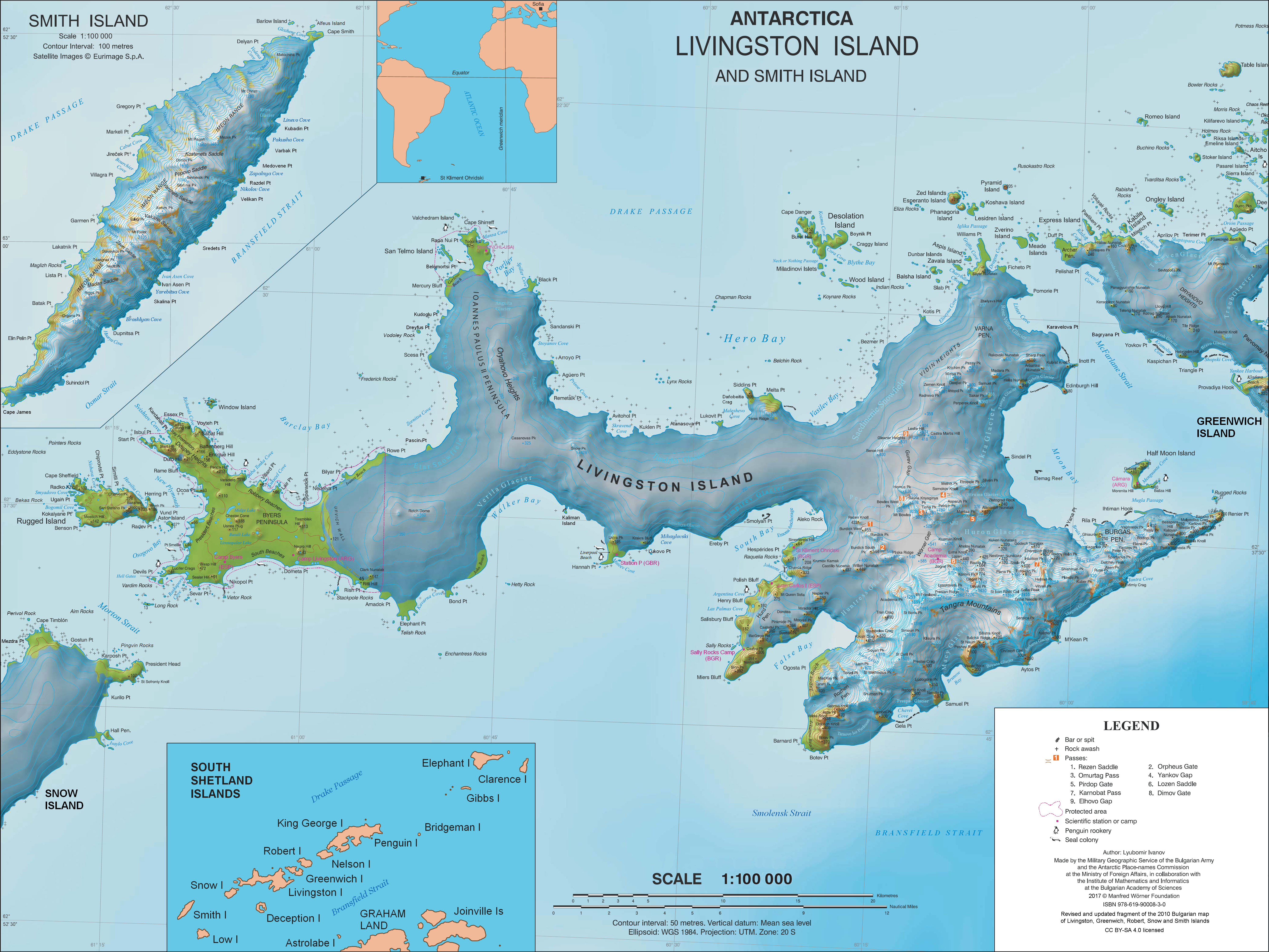
English: L.L. Ivanov. Antarctica: Livingston Island and Smith Island. Scale 1:100000 topographic map. Manfred Wörner Foundation, 2017. ISBN 978-619-90008-3-0 |
| Data | |
| Fonte | Opera propria |
| Autore | Apcbg |
| Licenza (Riusare questo file) |
Published by the Manfred Wörner Foundation under the Creative Commons Attribution ShareAlike 4.0 license. |
| Altre versioni | File:Livingston-Island-Map-2010.jpg, an earlier version |
Licenza
Io, detentore del copyright su quest'opera, dichiaro di pubblicarla con la seguente licenza:
Questo file è disponibile in base alla licenza Creative Commons Attribuzione-Condividi allo stesso modo 4.0 Internazionale
- Tu sei libero:
- di condividere – di copiare, distribuire e trasmettere quest'opera
- di modificare – di adattare l'opera
- Alle seguenti condizioni:
- attribuzione – Devi fornire i crediti appropriati, un collegamento alla licenza e indicare se sono state apportate modifiche. Puoi farlo in qualsiasi modo ragionevole, ma non in alcun modo che suggerisca che il licenziante approvi te o il tuo uso.
- condividi allo stesso modo – Se remixi, trasformi o sviluppi il materiale, devi distribuire i tuoi contributi in base alla stessa licenza o compatibile all'originale.
Cronologia del file
Fare clic su un gruppo data/ora per vedere il file come si presentava nel momento indicato.
| Data/Ora | Miniatura | Dimensioni | Utente | Commento | |
|---|---|---|---|---|---|
| attuale | 12:28, 2 apr 2021 | | 5 337 × 4 006 (9,65 MB) | Apcbg | update |
| 15:21, 27 giu 2019 |  | 5 337 × 4 006 (9,65 MB) | Apcbg | minor update | |
| 14:21, 23 mag 2019 |  | 5 337 × 4 006 (9,65 MB) | Apcbg | update | |
| 10:22, 19 mar 2019 |  | 5 337 × 4 006 (9,65 MB) | Apcbg | minor update | |
| 23:14, 9 feb 2019 |  | 5 337 × 4 006 (9,66 MB) | Apcbg | Update | |
| 17:35, 5 feb 2019 |  | 5 337 × 4 006 (9,66 MB) | Apcbg | Minor | |
| 21:20, 2 feb 2019 |  | 5 337 × 4 006 (9,66 MB) | Apcbg | Update | |
| 08:44, 9 ago 2018 |  | 5 337 × 4 006 (9,66 MB) | Apcbg | Update | |
| 08:17, 8 ago 2018 |  | 5 337 × 4 006 (9,66 MB) | Apcbg | Update | |
| 13:38, 31 mar 2017 |  | 5 337 × 4 006 (10,92 MB) | Apcbg | Updated topography and toponymy |
Pagine che usano questo file
Le seguenti 7 pagine usano questo file:
Utilizzo globale del file
Anche i seguenti wiki usano questo file:
- Usato nelle seguenti pagine di ar.wikipedia.org:
- Usato nelle seguenti pagine di ast.wikipedia.org:
- Usato nelle seguenti pagine di az.wikipedia.org:
- Usato nelle seguenti pagine di bg.wikipedia.org:
- Свети Климент Охридски (база)
- Ливингстън (остров)
- Тангра (планина)
- Монтана (връх)
- Академия (връх)
- Айтос (нос)
- Авитохол (нос)
- Цариград (връх)
- Лясковец (връх)
- Фрисланд (връх)
- Видински възвишения
- Куцото куче
- Свети Борис (връх)
- Симеон (връх)
- Варна (полуостров)
- Свети Иван Рилски (рид)
- Потребител:Dafosaddikk/Скала Белчин
- Скала Белчин
- Usato nelle seguenti pagine di ca.wikipedia.org:
- Usato nelle seguenti pagine di ceb.wikipedia.org:
- Usato nelle seguenti pagine di de.wikipedia.org:
- Livingston-Insel
- Table Island (Südliche Shetlandinseln)
- Barclay Bay
- Kap Shirreff
- Johannes-Paul-II.-Halbinsel
- Hero Bay
- Desolation Island (Südliche Shetlandinseln)
- Burdick Peak
- Black Point (Livingston-Insel)
- Blythe Bay
- Hemus Peak
- Leslie Hill (Livingston-Insel)
- Brunow Bay
- Bravo-Gletscher
- McFarlane Strait
- Renier Point
- Burdick South Peak
- Burdick West Peak
- Willan-Nunatak
- Plíska Ridge
- Rotch Dome
- Cora Cove
- Craggy Island (Südliche Shetlandinseln)
Visualizza l'utilizzo globale di questo file.