File proveniente da Wikimedia Commons. Clicca per visitare la pagina originale

File:View of Earth showing the Arctic, Europe, and Asia.jpg

Da Wikipedia, l'enciclopedia libera.
Vai alla navigazione Vai alla ricerca

File originale(12 000 × 12 000 pixel, dimensione del file: 36,77 MB, tipo MIME: image/jpeg)

Logo di Commons
Logo di Commons
Questo file e la sua pagina di descrizione (discussione · modifica) si trovano su Wikimedia Commons (?)

Dettagli

Descrizione
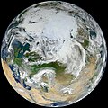
English: There have been many images of the full disc of Earth from space—a view often referred to as “the Blue Marble”—but few have looked quite like this. Using natural-color images from the Visible/Infrared Imaging Radiometer Suite (VIIRS) on the recently launched Suomi-NPP satellite, a NASA scientist has compiled a new view showing the Arctic and high latitudes.

Ocean scientist Norman Kuring of NASA’s Goddard Space Flight Center pieced together this composite image of Europe, Asia, North Africa, and the entire Arctic. It was compiled from 15 satellite passes made by Suomi-NPP on May 26, 2012. The spacecraft circles the Earth from pole to pole at an altitude of 824 kilometers (512 miles), so it takes multiple passes to gather enough data to show an entire hemisphere without gaps in the view.

Kuring stitched the image swaths together and then set up this view looking down from 70 degrees North, 60 degrees East. (That is, the view is artificial, as the satellite does not see the full disc at one time.) He was able to show the Arctic in this image because northern hemisphere spring spreads enough sunlight over the North Pole to allow a natural-light view.

VIIRS is a scanning radiometer that acquires data in 22 spectral bands, covering visible, near-infrared, and thermal infrared regions of the electromagnetic spectrum.
Data
Fonte https://oceancolor.gsfc.nasa.gov/gallery/404/
Autore NASA/NOAA. Image by Norman Kuring, NASA/GSFC/Suomi NPP. Caption by Michael Carlowicz. Suomi NPP is the result of a partnership between NASA, NOAA and the Department of Defense.

Licenza

Public domain Questo file è nel pubblico dominio perché creato dalla NASA. La politica sul copyright della NASA afferma che «il materiale della NASA non è protetto da copyright a meno che non sia specificato altrimenti». (NASA copyright policy e JPL Image Use Policy).
Attenzione:
Public domain
Questa immagine o file multimediale è di pubblico dominio poiché contiene materiale proveniente della National Oceanic and Atmospheric Administration, realizzato da personale dipendente durante l'assolvimento dei propri compiti ufficiali.

العربية  čeština  Deutsch  Zazaki  English  español  eesti  suomi  français  hrvatski  magyar  italiano  日本語  한국어  македонски  മലയാളം  Plattdüütsch  Nederlands  polski  português  română  русский  sicilianu  slovenščina  Türkçe  Tiếng Việt  简体中文  繁體中文  +/−

Didascalie

Aggiungi una brevissima spiegazione di ciò che questo file rappresenta

Elementi ritratti in questo file

raffigura

image/jpeg

Cronologia del file

Fare clic su un gruppo data/ora per vedere il file come si presentava nel momento indicato.

Data/OraMiniaturaDimensioniUtenteCommento
attuale05:12, 26 set 2023Miniatura della versione delle 05:12, 26 set 202312 000 × 12 000 (36,77 MB)Юрий Д.К.Uploaded a work by NASA/NOAA from https://oceancolor.gsfc.nasa.gov/gallery/404/ with UploadWizard

Le seguenti 2 pagine usano questo file:

Utilizzo globale del file

Anche i seguenti wiki usano questo file:

Metadati