File:Types of offshore oil and gas structures.jpg
Vai alla navigazione
Vai alla ricerca
Non sono disponibili versioni a risoluzione più elevata.
Types_of_offshore_oil_and_gas_structures.jpg (600 × 236 pixel, dimensione del file: 97 KB, tipo MIME: image/jpeg)
| Questo file e la sua pagina di descrizione (discussione · modifica) si trovano su Wikimedia Commons (?) |
Dettagli
| Descrizione |
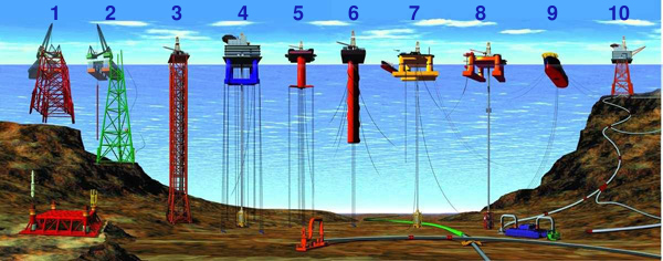
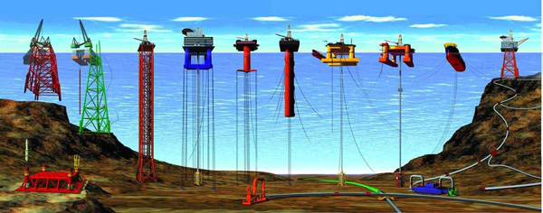
English: Types of Offshore Oil and Gas Structures
Deutsch: Arten von Öl- und Gasbohrinseln
|
| Data | Revised at 15 dicembre 2008 |
| Fonte | |
| Autore |
|
| Altre versioni |
|

Licenza
Questa immagine o file multimediale è di pubblico dominio poiché contiene materiale proveniente della National Oceanic and Atmospheric Administration, realizzato da personale dipendente durante l'assolvimento dei propri compiti ufficiali.
|
Cronologia del file
Fare clic su un gruppo data/ora per vedere il file come si presentava nel momento indicato.
| Data/Ora | Miniatura | Dimensioni | Utente | Commento | |
|---|---|---|---|---|---|
| attuale | 21:44, 25 ott 2013 | 600 × 236 (97 KB) | Jaybear | Numbers added; | |
| 19:56, 23 mag 2010 | 600 × 236 (72 KB) | Emerson7 | {{Information |Description = Types of offshore oil and gas structures incude: 1, 2) conventional fixed platforms (deepest: Shell’s Bullwinkle in 1991 at 412 m/1,353 ft GOM); 3) compliant tower (deepest: ChevronTexaco’s Petronius in 1998 at 534 m / |
Pagine che usano questo file
La seguente pagina usa questo file:
Utilizzo globale del file
Anche i seguenti wiki usano questo file:
- Usato nelle seguenti pagine di ar.wikipedia.org:
- Usato nelle seguenti pagine di cs.wikipedia.org:
- Usato nelle seguenti pagine di de.wikipedia.org:
- Usato nelle seguenti pagine di en.wikipedia.org:
- Usato nelle seguenti pagine di eo.wikipedia.org:
- Usato nelle seguenti pagine di es.wikipedia.org:
- Usato nelle seguenti pagine di fr.wikipedia.org:
- Usato nelle seguenti pagine di fy.wikipedia.org:
- Usato nelle seguenti pagine di gl.wikipedia.org:
- Usato nelle seguenti pagine di he.wikipedia.org:
- Usato nelle seguenti pagine di ja.wikipedia.org:
- Usato nelle seguenti pagine di nl.wikipedia.org:
- Usato nelle seguenti pagine di pl.wikipedia.org:
- Usato nelle seguenti pagine di pt.wikipedia.org:
- Usato nelle seguenti pagine di ru.wikipedia.org:
- Usato nelle seguenti pagine di sh.wikipedia.org:
- Usato nelle seguenti pagine di sk.wikipedia.org:
- Usato nelle seguenti pagine di sl.wikipedia.org:
- Usato nelle seguenti pagine di tr.wikipedia.org:
- Usato nelle seguenti pagine di uk.wikipedia.org:
- Usato nelle seguenti pagine di vi.wikipedia.org:
- Usato nelle seguenti pagine di zh-yue.wikipedia.org:
- Usato nelle seguenti pagine di zh.wikipedia.org: