File proveniente da Wikimedia Commons. Clicca per visitare la pagina originale

File:Tombstone fire insurance map 1888.jpg

Da Wikipedia, l'enciclopedia libera.
Vai alla navigazione Vai alla ricerca

File originale(8 000 × 3 794 pixel, dimensione del file: 7,25 MB, tipo MIME: image/jpeg)

Logo di Commons
Logo di Commons
Questo file e la sua pagina di descrizione (discussione · modifica) si trovano su Wikimedia Commons (?)
Descrizione
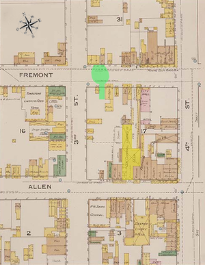
English: This map is one of over 700,000 fire insurance map sheets produced by the Sanborn Map Company for more than twelve thousand American cities and towns from the 1870s until the 1950s. These maps were prepared primarily to assist insurance underwriters in determining the risk involved in insuring individual properties.

The outline or footprint of each building is indicated, and the buildings are color coded to show the construction material (pink for brick; yellow for wood; brown for adobe). Numbers inside the lower right corner of each building indicate how many stories the building had, while the numbers outside the building on the street front refer to the street addresses, allowing researchers to correlate these locations with census records and city directories. Individual dwellings are marked with "D" or "Dwg." A legend is given at bottom right.

This image combines three maps published by Sanborne. The edges do not align in some instances due to drawing variances.
Data July 1888
Fonte Library of Congress
Creatore
New York: Sanborn Map and Publishing Company
Georeferencing Georeference the map in Wikimaps Warper If inappropriate please set warp_status = skip to hide.
Altre versioni

Annotated Sanborn map of Fremont Street, Arizona Territory.


Public domain

Quest'opera è nel pubblico dominio anche in tutti i Paesi e nelle aree in cui la durata del copyright è la vita dell'autore più 70 anni o meno.


Devi inserire anche un tag per il pubblico dominio relativo agli Stati Uniti per indicare perché quest'opera è nel pubblico dominio negli Stati Uniti. Nota che in alcuni Paesi i termini del copyright durano più di 70 anni: in Messico 100, in Giamaica 95, in Colombia 80, in Guatemala e Samoa 75 anni. Questa immagine potrebbe non essere nel pubblico dominio in questi Paesi, che inoltre non applicano la regola della durata più breve. L'Honduras ha un termine generale di 75 anni, ma questo paese applica la regola della durata più breve.

Didascalie

Aggiungi una brevissima spiegazione di ciò che questo file rappresenta
Clearly marked: 1886, not 1888.

Elementi ritratti in questo file

raffigura

Cronologia del file

Fare clic su un gruppo data/ora per vedere il file come si presentava nel momento indicato.

Data/OraMiniaturaDimensioniUtenteCommento
attuale06:23, 7 mar 2011Miniatura della versione delle 06:23, 7 mar 20118 000 × 3 794 (7,25 MB)BtphelpsSmaller version to eliminate errors with displaying larger image.
02:39, 23 feb 2011Miniatura della versione delle 02:39, 23 feb 201116 131 × 7 651 (21,1 MB)Btphelps{{Information |Description ={{en|1=This map is one of over 700,000 fire insurance map sheets produced by the Sanborn Map Company for more than twelve thousand American cities and towns from the 1870s until the 1950s. These maps were prepared primarily

La seguente pagina usa questo file:

Utilizzo globale del file

Anche i seguenti wiki usano questo file:

Metadati