File:South Island blizzard 2003.jpg
File originale (2 600 × 3 400 pixel, dimensione del file: 1,46 MB, tipo MIME: image/jpeg)
| Questo file e la sua pagina di descrizione (discussione · modifica) si trovano su Wikimedia Commons (?) |
|
Dettagli
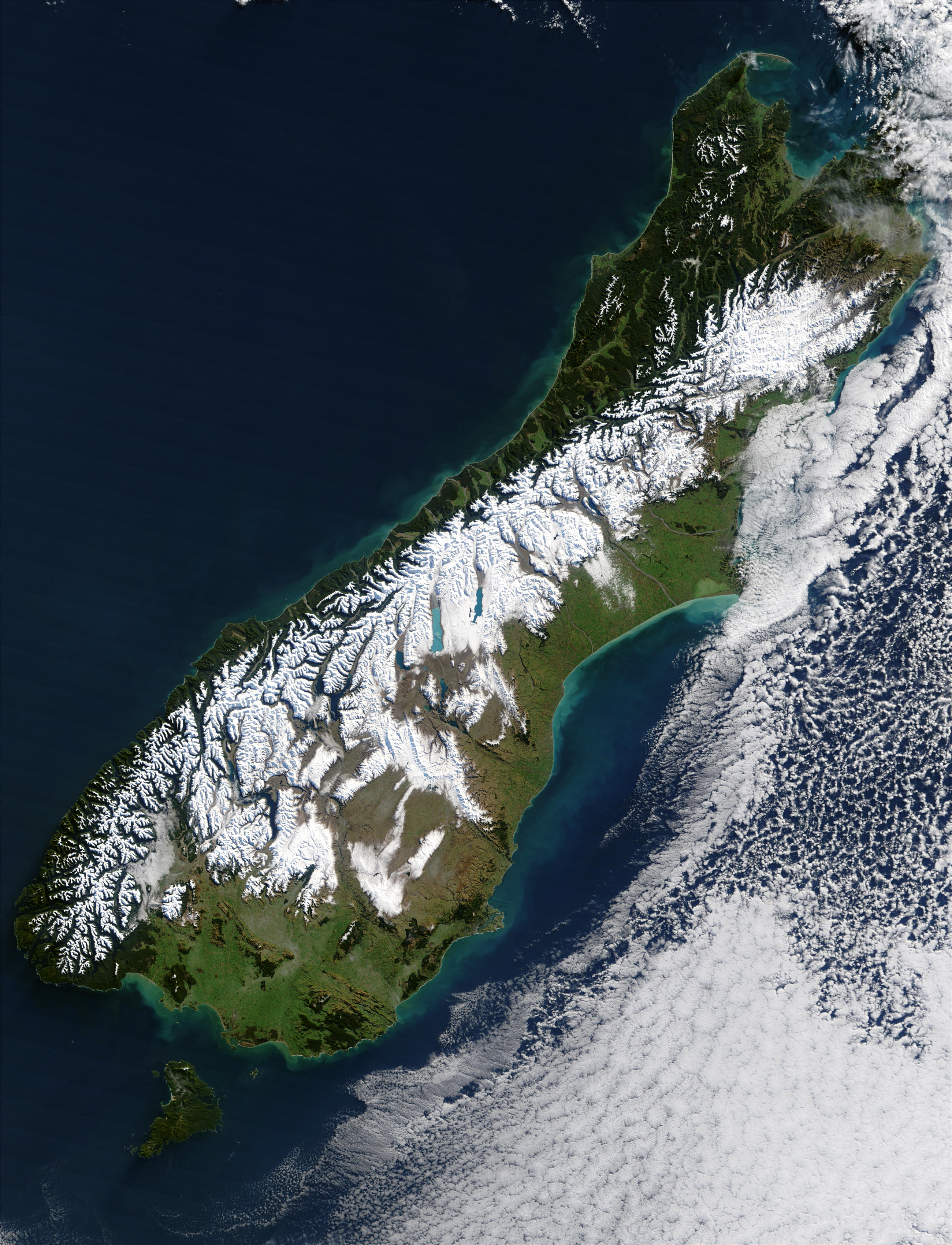
| Descrizione | This satellite image shows the aftermath of a severe blizzard that hit the South Island of New Zealand in July 2003. Higher regions are draped in snow, clearly delineating the escarpment northwest of the Southern Alps, formed by the 600 km (370 mi) long Alpine Fault. | |||||
| Data | ||||||
| Fonte | NASA's Earth Observatory | |||||
| Autore | Jacques Descloitres, MODIS Rapid Response Team at NASA GSFC | |||||
| Licenza (Riusare questo file) |
|
Blizzard in New Zealand
As the clouds broke over South Island, New Zealand, on July 11, 2003, clear skies revealed the blanket of snow that remained from what is being reported as the worst blizzard to hit the country in 50 years. The bright white snow contrasts sharply with the deep green vegetation of the coastal areas as well as with the bright blue, glacier-fed lakes scattered across the Southern Alps, which run diagonally across the island. The blizzard stranded hundreds of motorists and isolated more than 400 skiers at a mountain resort. In places, the storm brought ice and freezing rain, making roads especially treacherous and bringing down trees and power lines.
This image was captured by the Moderate Resolution Imaging Spectroradiometer (MODIS) on the Terra satellite. The high-resolution image provided above is 500 meters per pixel. The MODIS Rapid Response System provides this image at MODIS’ maximum spatial resolution of 250 meters.
Image courtesy Jacques Descloitres, MODIS Rapid Response Team at NASA GSFC.
SOURCE: http://earthobservatory.nasa.gov/NaturalHazards/shownh.php3?img_id=10797
”The purpose of NASA's Earth Observatory is to provide a freely-accessible publication on the Internet where the public can obtain new satellite imagery and scientific information about our home planet. The focus is on Earth's climate and environmental change. In particular, we hope our site is useful to public media and educators. Any and all materials published on the Earth Observatory are freely available for re-publication or re-use, except where copyright is indicated. We ask that NASA's Earth Observatory be given credit for its original materials.”
Image metadata (source):
2003/192 - 07/11 at 22 :35 UTC
South Island, New Zealand
Satellite: Terra
projection: Sinusoidal
image center lon: +170.5
image center lat: -44
UL lon: +166.6760
UL lat: -40.1783
UR lon: +174.3269
UR lat: -40.1783
LR lon: +174.8548
LR lat: -47.8225
LL lon: +166.1519
LL lat: -47.8225
UL easting (km): -324.7500
UL northing (km): -4467.7500
ellipsoid: Sphere
Earth radius (km): 6371.007181
Licenza
| Questo file è nel pubblico dominio perché creato dalla NASA. La politica sul copyright della NASA afferma che «il materiale della NASA non è protetto da copyright a meno che non sia specificato altrimenti». (NASA copyright policy e JPL Image Use Policy). | ||
 |
Attenzione:
|
Cronologia del file
Fare clic su un gruppo data/ora per vedere il file come si presentava nel momento indicato.
| Data/Ora | Miniatura | Dimensioni | Utente | Commento | |
|---|---|---|---|---|---|
| attuale | 15:32, 19 mag 2006 | | 2 600 × 3 400 (1,46 MB) | Avenue | == Summary == {{Information| |Description=This satellite image shows the aftermath of a severe blizzard that hit the South Island of New Zealand in July 2003. |Source=[http://earthobservatory.nasa.gov/NaturalHazards/shownh.php3?img_id=10797 NASA's Earth O |
Pagine che usano questo file
La seguente pagina usa questo file:
Utilizzo globale del file
Anche i seguenti wiki usano questo file:
- Usato nelle seguenti pagine di ast.wikipedia.org:
- Usato nelle seguenti pagine di de.wikipedia.org:
- Usato nelle seguenti pagine di en.wikipedia.org:
- Alpine Fault
- Talk:Alpine Fault
- Wikipedia:Featured pictures/Space/Looking back
- Wikipedia:Featured pictures thumbs/23
- Wikipedia:Featured picture candidates/June-2010
- Wikipedia:Featured picture candidates/South Island after 2003 blizzard
- Wikipedia:Wikipedia Signpost/2010-06-14/Features and admins
- User talk:Avenue/Archive5
- Wikipedia:Picture of the day/May 2015
- Template:POTD/2015-05-17
- Wikipedia:Main Page history/2015 May 17
- Wikipedia:Wikipedia Signpost/Single/2010-06-14
- User:Ric36/sandbox
- User talk:Avenue/Archive2012-2015
- Usato nelle seguenti pagine di id.wikipedia.org:
- Usato nelle seguenti pagine di no.wikipedia.org:
- Usato nelle seguenti pagine di pl.wikipedia.org:
- Usato nelle seguenti pagine di ru.wikipedia.org:
- Usato nelle seguenti pagine di uk.wikipedia.org:
- Usato nelle seguenti pagine di vi.wikipedia.org: