File:Rudaki CW0131770591G web.png
File originale (1 018 × 1 300 pixel, dimensione del file: 1,57 MB, tipo MIME: image/png)
| Questo file e la sua pagina di descrizione (discussione · modifica) si trovano su Wikimedia Commons (?) |
Dettagli
| Descrizione |
English: Date Acquired: October 6, 2008
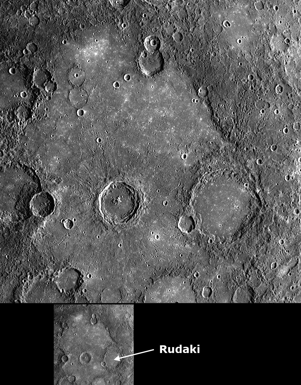
Image Mission Elapsed Time (MET): 131770591 Instrument: Wide Angle Camera (WAC) of the Mercury Dual Imaging System (MDIS) WAC Filter: 7 (750 nanometers) Resolution: 500 meters/pixel (0.31 miles/pixel) Scale: Rudaki crater has a diameter of 120 kilometers (75 miles) Spacecraft Altitude: 2,800 kilometers (1,700 miles) Of Interest: This WAC image shows a close-up view of the crater Rudaki, named for the Persian poet of the late 800s and early 900s. On the floor of Rudaki and also in a broad region surrounding Rudaki to the west are smooth plains, which are far less cratered than the neighboring terrain (except for the small secondary craters from the large, fresh crater to the west of Rudaki). Detailed studies of Mariner 10 images led to the conclusion that these plains near Rudaki were formed by volcanic flows on the surface of Mercury. This image from MESSENGER’s second flyby of Mercury shows some nice examples of craters in the plains that appear to have been significantly flooded with lava, leaving only their circular rims preserved. This WAC image is one of five scenes in a high-resolution color mosaic obtained just after MESSENGER’s closest approach to Mercury. Three of the other scenes have already been released: the first image after closest approach, a frame showing the craters Polygnotus and Boethius, and a view of Thākur crater. As was done to create the color composite images of Thākur crater, images acquired in all 11 of the WAC’s narrow-band color filters are being used to study the volcanic plains around Rudaki in more detail than was possible from the limited color data of the Mariner 10 mission. Credit: NASA/Johns Hopkins University Applied Physics Laboratory/Carnegie Institution of Washington |
| Data | |
| Fonte | http://messenger.jhuapl.edu/gallery/sciencePhotos/image.php?page=2&gallery_id=2&image_id=254 |
| Autore | NASA/Johns Hopkins University Applied Physics Laboratory/Carnegie Institution of Washington |
Licenza
| Questo file è nel pubblico dominio perché creato dalla NASA. La politica sul copyright della NASA afferma che «il materiale della NASA non è protetto da copyright a meno che non sia specificato altrimenti». (NASA copyright policy e JPL Image Use Policy). | ||
 |
Attenzione:
|
Cronologia del file
Fare clic su un gruppo data/ora per vedere il file come si presentava nel momento indicato.
| Data/Ora | Miniatura | Dimensioni | Utente | Commento | |
|---|---|---|---|---|---|
| attuale | 21:02, 13 giu 2009 | | 1 018 × 1 300 (1,57 MB) | Bryan Derksen | {{Information |Description={{en|1= Date Acquired: October 6, 2008 Image Mission Elapsed Time (MET): 131770591 Instrument: Wide Angle Camera (WAC) of the Mercury Dual Imaging System (MDIS) WAC Filter: 7 (750 nanometers) Resolution: 500 meters/pixel (0.31 m |
Pagine che usano questo file
Le seguenti 2 pagine usano questo file:
Utilizzo globale del file
Anche i seguenti wiki usano questo file:
- Usato nelle seguenti pagine di ca.wikipedia.org:
- Usato nelle seguenti pagine di ce.wikipedia.org:
- Usato nelle seguenti pagine di en.wikipedia.org:
- Usato nelle seguenti pagine di fa.wikipedia.org:
- Usato nelle seguenti pagine di uk.wikipedia.org:
- Usato nelle seguenti pagine di www.wikidata.org: