File:Rand, McNally and Co. Map of the Houston and Texas Central Railway 1880 UTA.jpg
Vai alla navigazione
Vai alla ricerca

Dimensioni di questa anteprima: 596 × 600 pixel. Altre risoluzioni: 239 × 240 pixel | 477 × 480 pixel | 763 × 768 pixel | 1 018 × 1 024 pixel | 2 036 × 2 048 pixel | 8 476 × 8 528 pixel.
File originale (8 476 × 8 528 pixel, dimensione del file: 11,04 MB, tipo MIME: image/jpeg)
| Questo file e la sua pagina di descrizione (discussione · modifica) si trovano su Wikimedia Commons (?) |
Dettagli
| Titolo |
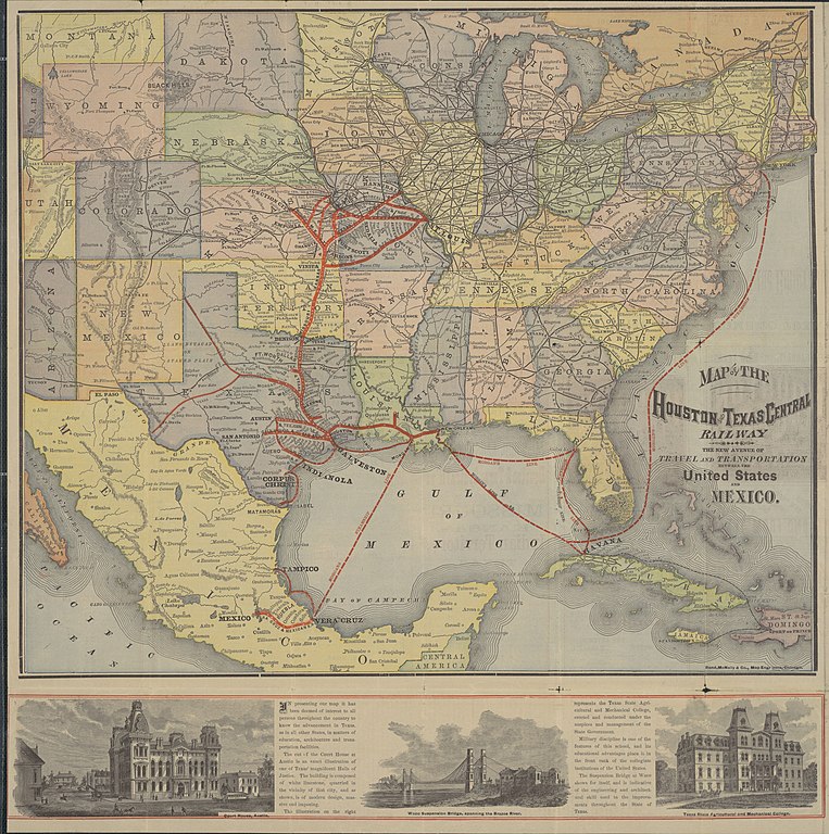
English: Map of the Houston and Texas Central Railway. The New Avenue of Travel and Transportation Between the United States and Mexico |
||||||||||||||||||||||||||
| Descrizione |
English: This folding railroad promotional brochure map is a fine example of a late nineteenth-century American railway map by one of the most important American railway mapmakers and publishers still in business today: Rand, McNally and Company of Chicago. Established in 1858 as a printing company, by 1873 the firm was known for its railroad related work and had also opened a map department where they advertised "all kinds of Relief Plate Engraving [cerography or wax engraving]". The heavy lines with evenly spaced dots emphasize the main railroad lines, and each dot represents a "whistle-stop" or station where the train would let off and take on passengers and freight. This was, and still is, a characteristic feature of many railroad and subway maps which simplify, exaggerate, and distort distances, area, and direction in order to convey key information. Although the Houston and Texas Central Railway is the central focus of the map, it also delineates the railroad's integration with New York shipping and railroad magnate Charles W. Morgan's steamship lines, the Texas and New Orleans, the Galveston, Harrisburg and San Antonio, the Missouri, Kansas and Texas, and other railroads.
|
||||||||||||||||||||||||||
| Data | |||||||||||||||||||||||||||
| Fonte | UTA Libraries Cartographic Connections: mappa / testo | ||||||||||||||||||||||||||
| Creatore |
Houston and Texas Central Railway Rand, McNally & Company |
||||||||||||||||||||||||||
| Attribuzione |
English: The University of Texas at Arlington Libraries Special Collections |
||||||||||||||||||||||||||
| Geotemporal data | |||||||||||||||||||||||||||
| Map location |
Stati Uniti d'America Messico |
||||||||||||||||||||||||||
| Georeferencing | If inappropriate please set warp_status = skip to hide. | ||||||||||||||||||||||||||
| Bibliographic data | |||||||||||||||||||||||||||
| Luogo di pubblicazione | Chicago | ||||||||||||||||||||||||||
| Stampato da |
Rand, McNally and Company (for the Houston and Texas Central Railway) |
||||||||||||||||||||||||||
| Archival data | |||||||||||||||||||||||||||
| Collezione |
|
||||||||||||||||||||||||||
| Dimensioni | altezza: 50 cm; larghezza: 50 cm | ||||||||||||||||||||||||||
| Tecnica/materiale | cerograph a colori | ||||||||||||||||||||||||||
| artwork-references |
Modelski Railroad Maps of North America, pp. xvi-xx Vivian Elizabeth Smyrl. Waco Suspension Bridge. Handbook of Texas Online. Retrieved on April 2, 2022. Buisseret, David; Richard Francaviglia, Gerald Saxon, and Jack W. Graves, Jr. (2009) Historic Texas From the Air, Austin: University of Texas Press, pp. 112−113 Baughman, James P. (1968) Charles Morgan and the Development of Southern Transportation, Nashville: Vanderbilt University Press Francaviglia, Richard V. (1998) From Sail to Steam: Four Centuries of Texas Maritime History, 1500-1900, Austin: University of Texas Press, p. 128ff |
||||||||||||||||||||||||||
| Altre versioni | |||||||||||||||||||||||||||
.jpg)
.jpg)
.jpg)
Licenza

|
This file was provided to Wikimedia Commons by the University of Texas at Arlington Libraries as part of a cooperation project. The University of Texas at Arlington Libraries is part of the University of Texas at Arlington, a public research university located in Arlington, Texas.
|
This work was published before January 1, 1929 and it is anonymous or pseudonymous due to unknown authorship. It is in the public domain in the United States as well as countries and areas where the copyright terms of anonymous or pseudonymous works are 95 years or fewer since publication.
|
Cronologia del file
Fare clic su un gruppo data/ora per vedere il file come si presentava nel momento indicato.
| Data/Ora | Miniatura | Dimensioni | Utente | Commento | |
|---|---|---|---|---|---|
| attuale | 23:37, 2 apr 2022 | | 8 476 × 8 528 (11,04 MB) | Michael Barera | == {{int:filedesc}} == {{Map |title = {{en|'''''Map of the Houston and Texas Central Railway. The New Avenue of Travel and Transportation Between the United States and Mexico'''''}} |description = {{en|This folding railroad promotional brochure map is a fine example of a late nineteenth-century American railway map by one of the most important American railway mapmakers and publishers still in business today: Rand, McNally and Company of Chicago. Established in 1858 as a p... |
Pagine che usano questo file
La seguente pagina usa questo file:
Utilizzo globale del file
Anche i seguenti wiki usano questo file:
- Usato nelle seguenti pagine di en.wikipedia.org:
- Usato nelle seguenti pagine di fr.wikipedia.org: