File:Pevtsov routes.jpg

File originale (2 832 × 1 868 pixel, dimensione del file: 4,15 MB, tipo MIME: image/jpeg)
| Questo file e la sua pagina di descrizione (discussione · modifica) si trovano su Wikimedia Commons (?) |
Dettagli
| Descrizione |
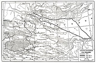
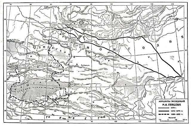
This map of Eastern Turkestan and Mongolia can be found on p. 5 in Путешествие в Кашгарию и Кун-Лунь [Journey to Kashgaria and Kunlun], written by the Russian explorer M. V. Pevtsov and published in 1949. It is a pencil sketch map marking out the different travel routes made by the author between the years 1876 and 1890. According to the map, Pevtsov traveled in the Dzungaria region north of the Tian Shan Mountains in 1876, in Mongolia and through the Gobi Desert in 1878-1879, and in Kashgaria and the Kunlun Mountains in 1889-1890. The book contains two more maps, one showing the Kashgaria region in greater detail, and the other the travel routes of other prominent Russian explorers in the same region |
|||||||||
| Data | made pre 1902, 1949 published | |||||||||
| Fonte | http://www.jarringcollection.se/maps/routes/trv043m1/ Путешествие в Кашгарию и Кун-Лунь [Journey to Kashgaria and Kunlun] | |||||||||
| Creatore |
M.V. Pevtsov |
|||||||||
| Licenza (Riusare questo file) |
|
|||||||||
| Geotemporal data | ||||||||||
| Bounding box |
|
|||||||||
| Georeferencing | ||||||||||
Cronologia del file
Fare clic su un gruppo data/ora per vedere il file come si presentava nel momento indicato.
| Data/Ora | Miniatura | Dimensioni | Utente | Commento | |
|---|---|---|---|---|---|
| attuale | 14:49, 26 feb 2021 | | 2 832 × 1 868 (4,15 MB) | Shyamal | {{Map |Description=This map of Eastern Turkestan and Mongolia can be found on p. 5 in Путешествие в Кашгарию и Кун-Лунь [Journey to Kashgaria and Kunlun], written by the Russian explorer M. V. Pevtsov and published in 1949. It is a pencil sketch map marking out the different travel routes made by the author between the years 1876 and 1890. According to the map, Pevtsov traveled in the Dzungaria region north of the Tian Shan Mountains in 1876, in Mongolia and through the Gobi Desert in 1878-18... |
Pagine che usano questo file
La seguente pagina usa questo file:
Utilizzo globale del file
Anche i seguenti wiki usano questo file:
- Usato nelle seguenti pagine di en.wikipedia.org: