File:PIA21130 Signs of Schiaparelli Test Lander Seen From Orbit.gif

File originale (1 132 × 781 pixel, dimensione del file: 1,43 MB, tipo MIME: image/gif, ciclico, 2 frame, 2,0 s)
| Questo file e la sua pagina di descrizione (discussione · modifica) si trovano su Wikimedia Commons (?) |
Dettagli
| Descrizione |
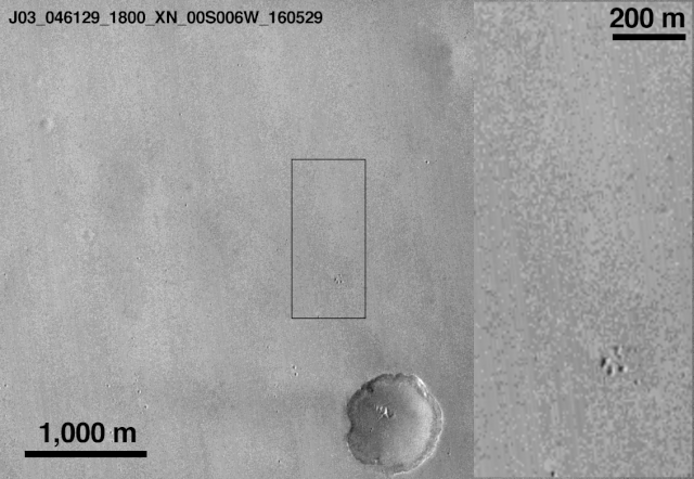
English: This comparison of before-and-after images shows two spots that likely appeared in connection with the Oct. 19, 2016, Mars arrival of the European Space Agency's Schiaparelli test lander.
The images were taken by the Context Camera (CTX) on NASA's Mars Reconnaissance Orbiter on May 29, 2016, and Oct. 20, 2016. The area indicated with a black outline is enlarged at right. The bright spot near the lower edge of the enlargement is interpreted as likely to be the lander's parachute, which was deployed and then released during the descent through the Martian atmosphere. The larger dark spot near the upper edge of the enlargement was likely formed by the Schiaparelli lander. The spot is elliptical, about 50 by 130 feet (15 by 40 meters) in size, and is probably too large to have been made by the impact of the heat shield. The location information confirmed by this image will aid imaging the site with the High Resolution Imaging Science Experiment (HiRISE) camera, providing more details to use in interpretation. The main image covers an area about 2.5 miles (4 kilometers) wide, at about 2 degrees south latitude, 354 degrees east longitude, in the Meridiani Planum region of Mars. The scale bars are in meters. North is up. The before and after images are available separately as Figure 1 (from CTX observation J03_046129_1800) and Figure 2 (from CTX observation J08_047975_1779). CTX was built by and is operated by Malin Space Science Systems, San Diego. NASA's Jet Propulsion Laboratory, a division of Caltech in Pasadena, California, manages the Mars Reconnaissance Orbiter Project for NASA's Science Mission Directorate, Washington. |
| Data | (published) |
| Fonte | Catalog page · Full-res (GIF) |
| Autore | NASA/JPL-Caltech/MSSS |
| Altre versioni |
|


| Location on Mars | Posizione di questa e altre immagini su: Google Maps |
|---|
Questa immagine o filmato è stato catalogato dal Jet Propulsion Lab della National Aeronautics and Space Administration (NASA) degli Stati Uniti d'Americacon il Photo ID: PIA21132.Questo tag non indica lo status del copyright dell'opera ad esso associato. È quindi richiesto un normale tag di copyright. Vedi Commons:Licenze per maggiori informazioni. Altre lingue:
|
 |
This media is a product of the Mars Reconnaissance Orbiter mission Credit and attribution belongs to the MRO Context Camera (CTX) team, NASA/JPL-Caltech/MSSS |
Licenza
| Questo file è nel pubblico dominio perché creato dalla NASA. La politica sul copyright della NASA afferma che «il materiale della NASA non è protetto da copyright a meno che non sia specificato altrimenti». (NASA copyright policy e JPL Image Use Policy). | ||
 |
Attenzione:
|
Cronologia del file
Fare clic su un gruppo data/ora per vedere il file come si presentava nel momento indicato.
| Data/Ora | Miniatura | Dimensioni | Utente | Commento | |
|---|---|---|---|---|---|
| attuale | 20:28, 21 ott 2016 | | 1 132 × 781 (1,43 MB) | Ely1 | User created page with UploadWizard |
Pagine che usano questo file
Le seguenti 2 pagine usano questo file:
Utilizzo globale del file
Anche i seguenti wiki usano questo file:
- Usato nelle seguenti pagine di de.wikipedia.org:
- Usato nelle seguenti pagine di en.wikipedia.org:
- Usato nelle seguenti pagine di es.wikinews.org:
- Usato nelle seguenti pagine di et.wikipedia.org:
- Usato nelle seguenti pagine di fa.wikipedia.org:
- Usato nelle seguenti pagine di fr.wikipedia.org:
- Usato nelle seguenti pagine di he.wikipedia.org:
- Usato nelle seguenti pagine di ru.wikipedia.org:
- Usato nelle seguenti pagine di ru.wikinews.org: