File:PIA16189 fig1-Curiosity Rover-Rock Outcrops-Mars and Earth.jpg

File originale (959 × 717 pixel, dimensione del file: 681 KB, tipo MIME: image/jpeg)
| Questo file e la sua pagina di descrizione (discussione · modifica) si trovano su Wikimedia Commons (?) |
Dettagli
| Descrizione |
English: 09.26.2012
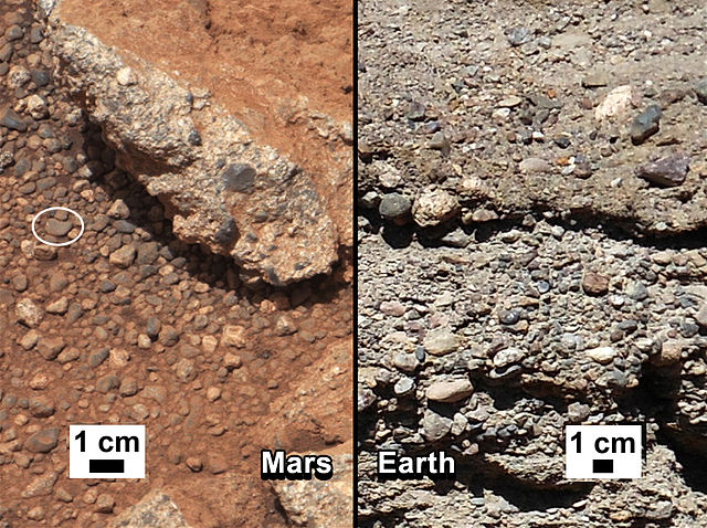
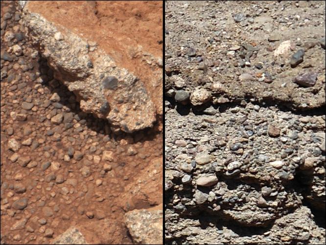
Rock Outcrops on Mars and Earth This set of images compares the Link outcrop of rocks on Mars (left) with similar rocks seen on Earth (right). The image of Link, obtained by NASA's Curiosity rover, shows rounded gravel fragments, or clasts, up to a couple inches (few centimeters), within the rock outcrop. Erosion of the outcrop results in gravel clasts that fall onto the ground, creating the gravel pile at left. The outcrop characteristics are consistent with a sedimentary conglomerate, or a rock that was formed by the deposition of water and is composed of many smaller rounded rocks cemented together. A typical Earth example of sedimentary conglomerate formed of gravel fragments in a stream is shown on the right. An annotated version of the image highlights a piece of gravel that is about 0.4 inches (1 centimeter) across. It was selected as an example of coarse size and rounded shape. Rounded grains (of any size) occur by abrasion in sediment transport, by wind or water, when the grains bounce against each other. Gravel fragments are too large to be transported by wind. At this size, scientists know the rounding occurred in water transport in a stream. The name Link is derived from a significant rock formation in the Northwest Territories of Canada, where there is also a lake with the same name. Scientists enhanced the color in the Mars image to show the scene as it would appear under the lighting conditions we have on Earth, which helps in analyzing the terrain. The Link outcrop was imaged with the 100-millimeter Mast Camera on Sept. 2, 2012, which was the 27th sol, or Martian day of operations. Polski: Wychodnie skalne na Marsie i na Ziemi Przedstawiony zestaw dwóch zdjęć porównuje odkrywkię skał o nazwie Link na Marsie (z lewej), z podobnymi skałami na Ziemi (po prawej). Zdjęcie odkrywki Link, uzyskane przez należący do NASA łazik Curiosity, pokazuje zaokrąglone fragmenty żwiru lub zlepieńców, o rozmiarach dochodzących do kilku centymetrów. Erozja wychodni powoduje rozpadanie się konglomeratów żwiru, które opadają na ziemię, tworząc stertę żwiru po lewej stronie. Charakterystyczne cechy odkrywki są zgodne z cechami litej skały osadowej, złożonej z ziaren żwiru scementowanych lepiszczem, albo skały, która powstała w wyniku osadzania się wody i zbudowana jest z wielu mniejszych zaokrąglonych i spojonych skał. Typowy przykład konglomeratu skał osadowych tworzonych na Ziemi z żwirowych fragmentów w strumieniu, pokazany jest na prawym zdjęciu. Na opisanej wersji zdjęcia (wersja nieopisana) jest zaznaczony żwirowy kamień o średnicy około 1 centymetra, jako przykład kamienia znacznej wielkości i zaokrąglonego kształtu. Zaokrąglone ziarna (dowolnej wielkości) powstają w transporcie rumowiska, przez wiatr lub wodę, poprzez ścieranie, podczas gdy ziarna obijają się wzajemnie o siebie. Podczas gdy fragmenty żwiru są zbyt duże, aby mogły być transportowane przez wiatr, zdaniem naukowców, zaokrąglenie ziaren żwiru występuje w transporcie za pośrednictwem wody w strumieniu. Nazwa Link pochodzi od znaczącej formacji skalnej znajdującej się na terytorium Północno-Zachodniej Kanady, gdzie znajduje się również jezioro o tej samej nazwie. Naukowcy poprawili kolory zdjęcia, aby pokazać, wychodnię w takich warunkach oświetleniowych, jakie mamy na Ziemi, co pomaga w analizie obrazu. Odkrywka Link została sfotografowana kamerą masztową z obiektywem o 100-milimetrowej ogniskowej, w dniu 2 września 2012 roku, lub w sol 27, albo w 27 marsjańskim dniu misji łazika Curiosity na powierzchni Marsa. Image Credit: NASA/JPL-Caltech/MSSS and PSI |
| Data | |
| Fonte | http://photojournal.jpl.nasa.gov/figures/PIA16189_fig1.jpg |
| Autore | NASA/JPL-Caltech/MSSS and PSI |
| Altre versioni | http://photojournal.jpl.nasa.gov/catalog/PIA16189 |
Licenza
| Questo file è nel pubblico dominio perché creato dalla NASA. La politica sul copyright della NASA afferma che «il materiale della NASA non è protetto da copyright a meno che non sia specificato altrimenti». (NASA copyright policy e JPL Image Use Policy). | ||
 |
Attenzione:
|
| Annotazioni | Questa immagine è annotata: Vedi le annotazioni su Commons |
Cronologia del file
Fare clic su un gruppo data/ora per vedere il file come si presentava nel momento indicato.
| Data/Ora | Miniatura | Dimensioni | Utente | Commento | |
|---|---|---|---|---|---|
| attuale | 02:12, 1 ott 2012 | | 959 × 717 (681 KB) | Drbogdan | User created page with UploadWizard |
Pagine che usano questo file
Le seguenti 3 pagine usano questo file:
Utilizzo globale del file
Anche i seguenti wiki usano questo file:
- Usato nelle seguenti pagine di bn.wikipedia.org:
- Usato nelle seguenti pagine di ca.wikipedia.org:
- Usato nelle seguenti pagine di en.wikipedia.org:
- Usato nelle seguenti pagine di es.wikipedia.org:
- Usato nelle seguenti pagine di fa.wikipedia.org:
- Usato nelle seguenti pagine di fr.wikipedia.org:
- Usato nelle seguenti pagine di ja.wikipedia.org:
- Usato nelle seguenti pagine di kk.wikipedia.org:
- Usato nelle seguenti pagine di nl.wikipedia.org:
- Usato nelle seguenti pagine di pl.wikipedia.org:
- Usato nelle seguenti pagine di pnb.wikipedia.org:
- Usato nelle seguenti pagine di ro.wikipedia.org:
- Usato nelle seguenti pagine di ru.wikipedia.org:
- Usato nelle seguenti pagine di sr.wikipedia.org:
- Usato nelle seguenti pagine di test.wikipedia.org:
- Usato nelle seguenti pagine di uk.wikipedia.org:
- Usato nelle seguenti pagine di ur.wikipedia.org:
- Usato nelle seguenti pagine di zh.wikipedia.org: