File:Myanmar civil war.svg

File originale (file in formato SVG, dimensioni nominali 1 228 × 2 003 pixel, dimensione del file: 1,3 MB)
| Questo file e la sua pagina di descrizione (discussione · modifica) si trovano su Wikimedia Commons (?) |

|
Questo file può essere aggiornato per contenere nuove informazioni. Se si desidera utilizzare una versione specifica del file senza i nuovi aggiornamenti, è necessario caricare la versione richiesta in un file separato. |
Dettagli
| Descrizione |
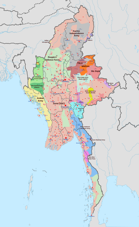
English: A map of the Myanmar civil war (2021–present)
|
| Data | |
| Fonte | Opera propria derivate of Myanmar adm location map.svg di NordNordWest. Citing @ThomasVLinge |
| Autore | Ecrusized |
| Altre versioni |
|

This file is translated using SVG For most Wikipedia projects, you can embed the file normally (without a To translate the text into your language, you can use the SVG Translate tool. Alternatively, you can download the file to your computer, add your translations using whatever software you're familiar with, and re-upload it with the same name. You will find help in Graphics Lab if you're not sure how to do this. |
Licenza
| Questo file è reso disponibile nei termini della licenza Creative Commons CC0 1.0 Universal. | |
| La persona che ha associato un'opera con questo atto legale ha donato tale opera nel pubblico dominio rinunciando a tutti i diritti sull'opera in tutto il mondo, inclusi tutti i diritti connessi o altri diritti simili, per quanto permesso dalla legge. Puoi copiare, modificare, distribuire ed utilizzare l'opera, anche a fini commerciali, senza chiedere alcun permesso.
|
Cronologia del file
Fare clic su un gruppo data/ora per vedere il file come si presentava nel momento indicato.
| Data/Ora | Miniatura | Dimensioni | Utente | Commento | |
|---|---|---|---|---|---|
| attuale | 12:32, 30 apr 2024 | | 1 228 × 2 003 (1,3 MB) | MrBLOCKiron | Continuation of yesterdays edit, check april 29 discussion. |
| 18:45, 29 apr 2024 |  | 1 228 × 2 003 (1,3 MB) | MrBLOCKiron | Update, check talk page for notes and sources | |
| 20:46, 17 apr 2024 |  | 1 228 × 2 003 (1,29 MB) | EmeraldRange | Updating Myawaddy area to reflect territory taken - Shwekoko to the north and Thinganyinaung to the west as per Talk on en:Myanmar civil war (2021-present) | |
| 05:01, 12 apr 2024 |  | 1 228 × 2 003 (1,3 MB) | PequodOnStationAtLZ | updated to reflect rebel capture of myawaddy | |
| 22:52, 4 apr 2024 |  | 1 228 × 2 003 (1,3 MB) | EmeraldRange | Updated based on Timelines , sources and new map from van Linge; see File Talk/Discusion for sources | |
| 17:35, 23 mar 2024 |  | 1 228 × 2 003 (1,29 MB) | TheWasalpha | Capture of Rathedaung last week by AA, removed a misplaced dot in Bangladesh | |
| 18:47, 17 mar 2024 |  | 1 228 × 2 003 (1,29 MB) | EmeraldRange | Updated with other items to March 17, see File Talk/Discussion | |
| 08:32, 16 mar 2024 |  | 1 228 × 2 003 (1,27 MB) | Hoben7599 | See discussion for source links | |
| 17:12, 21 feb 2024 |  | 1 228 × 2 003 (1,27 MB) | EmeraldRange | Updated to include Myebon capture, Mabein capture and AA territory updates based on source from Talk:Myanmar civil war. (See discussion for source links) | |
| 05:25, 16 feb 2024 |  | 1 228 × 2 003 (1,27 MB) | EmeraldRange | fixed wrong layering for Karenni |
Pagine che usano questo file
La seguente pagina usa questo file:
Utilizzo globale del file
Anche i seguenti wiki usano questo file:
- Usato nelle seguenti pagine di ar.wikipedia.org:
- Usato nelle seguenti pagine di en.wikipedia.org:
- Usato nelle seguenti pagine di es.wikipedia.org:
- Usato nelle seguenti pagine di et.wikipedia.org:
- Usato nelle seguenti pagine di fa.wikipedia.org:
- Usato nelle seguenti pagine di fr.wikipedia.org:
- Usato nelle seguenti pagine di hu.wikipedia.org:
- Usato nelle seguenti pagine di ja.wikipedia.org:
- Usato nelle seguenti pagine di ko.wikipedia.org:
- Usato nelle seguenti pagine di ms.wikipedia.org:
- Usato nelle seguenti pagine di my.wikipedia.org:
- Usato nelle seguenti pagine di pt.wikipedia.org:
- Usato nelle seguenti pagine di ru.wikipedia.org:
- Usato nelle seguenti pagine di th.wikipedia.org:
- Usato nelle seguenti pagine di uk.wikipedia.org:
- Usato nelle seguenti pagine di zh.wikipedia.org: