File:Messina-waves-image.jpg
Vai alla navigazione
Vai alla ricerca

Dimensioni di questa anteprima: 387 × 600 pixel. Altre risoluzioni: 155 × 240 pixel | 309 × 480 pixel | 495 × 768 pixel | 660 × 1 024 pixel | 1 321 × 2 048 pixel | 3 870 × 6 000 pixel.
File originale (3 870 × 6 000 pixel, dimensione del file: 4,28 MB, tipo MIME: image/jpeg)
| Questo file e la sua pagina di descrizione (discussione · modifica) si trovano su Wikimedia Commons (?) |
| Descrizione |
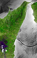
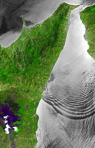
English: The Strait of Messina is a narrow channel separating the island of Sicily from the Italian peninsula, connecting the Ionian Sea with the Tyrrhenian Sea. In the Strait, strong tidal currents occur, which interact with the shallow sill located in its center. The mean depth of the Strait is only 80 m, compared to depths of over 800 m to the south. Internal wave trains of solitary waves can be generated, and these show up as sea surface manifestations because they are associated with variable surface currents that modify the surface roughness. ASTER sees these as dark (smooth) and light (rough) patterns when the solar illumination is at the correct angle relative to the orientation of the satellite. The ASTER images cover an area of 58 km x 90 km.
Deutsch: Die Straße von Messina ist eine Meerenge, die die Insel Sizilien von der italienischen Halbinsel trennt und das Ionische Meer mit dem Tyrrhenischen Meer verbindet. Hier treten starke Gezeitenströmungen auf, die mit der flachen Schwelle in ihrer Mitte interagieren. Die durchschnittliche Tiefe der Meerenge beträgt nur 80 m, im Vergleich zu Tiefen von über 800 m im Süden. Solitärwellen können Züge von internen Wellen erzeugen, und diese wirken auf die Meeresoberfläche, weil sie sich mit variablen Oberflächenströmungen überlagern und dabei die Oberflächenrauheit verändern. ASTER sieht diese Erscheinungen als dunkle (glatte) und helle (raue) Muster, wenn die Sonnenbeleuchtung im richtigen Winkel zur Ausrichtung des Satelliten steht. Die ASTER-Aufnahmen erstrecken sich über eine Fläche von 58 km x 90 km. |
| Data | |
| Fonte | http://asterweb.jpl.nasa.gov/gallery-detail.asp?name=messina-wave |
| Autore |
NASA/GSFC/METI/ERSDAC/JAROS, and U.S./Japan ASTER Science Team |
| Posizione del soggetto | | Posizione di questa e altre immagini su: OpenStreetMap |
|---|
Licenza
| Questo file è nel pubblico dominio perché creato dalla NASA. La politica sul copyright della NASA afferma che «il materiale della NASA non è protetto da copyright a meno che non sia specificato altrimenti». (NASA copyright policy e JPL Image Use Policy). | ||
 |
Attenzione:
|
Registro originale del caricamento
La pagina di descrizione originale era qui. Tutti i nomi utente che seguono sono riferiti a de.wikipedia.
| Upload date | User | Bytes | Dimensions | Comment |
|---|---|---|---|---|
| 2009-06-02 22:17:24 | Herbertweidner | 4484167 | 3870×6000 | {{Information |Beschreibung = The Strait of Messina is a narrow channel separating the island of Sicily from the Italian peninsula, connecting the Ionian Sea with the Tyrrhenian Sea. In the Strait, strong tidal currents occur, which interact with the shal |
Cronologia del file
Fare clic su un gruppo data/ora per vedere il file come si presentava nel momento indicato.
| Data/Ora | Miniatura | Dimensioni | Utente | Commento | |
|---|---|---|---|---|---|
| attuale | 02:31, 29 mar 2010 | | 3 870 × 6 000 (4,28 MB) | CommonsHelper2 Bot | {{BotMoveToCommons|de.wikipedia|year={{subst:CURRENTYEAR}}|month={{subst:CURRENTMONTHNAME}}|day={{subst:CURRENTDAY}}}} {{Information |Description = {{de |The Strait of Messina is a narrow channel separating the island of Sicily from the Italian peninsul |
Pagine che usano questo file
Le seguenti 2 pagine usano questo file:
Utilizzo globale del file
Anche i seguenti wiki usano questo file:
- Usato nelle seguenti pagine di da.wikipedia.org:
- Usato nelle seguenti pagine di de.wikipedia.org:
- Usato nelle seguenti pagine di en.wikipedia.org:
- Usato nelle seguenti pagine di es.wikipedia.org:
- Usato nelle seguenti pagine di nl.wikipedia.org:
- Usato nelle seguenti pagine di simple.wikipedia.org:
- Usato nelle seguenti pagine di www.wikidata.org: