File:Map Denmark Demis SE islands.gif
Vai alla navigazione
Vai alla ricerca
Non sono disponibili versioni a risoluzione più elevata.
Map_Denmark_Demis_SE_islands.gif (415 × 420 pixel, dimensione del file: 23 KB, tipo MIME: image/gif)
| Questo file e la sua pagina di descrizione (discussione · modifica) si trovano su Wikimedia Commons (?) |
Dettagli
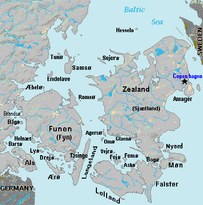
| Descrizione | Terrain map of southeast Denmark, showing the major islands labeled, in the region between Germany and Sweden. The terrain data was extracted from the Demis map (on Wikimedia Commons) Image:La2-demis-denmark.png, and the extracted map was color-shifted to grayshade land areas (from the green Demis map). Labels are in font face Arial or Arial Narrow, sizes 8-10. |
| Data | |
| Fonte | Derivative of Demis map: Image:La2-demis-denmark.png |
| Autore | Wikid77 (derivative of Demis map) |
Licenza
This image is in the public domain because it came from the site https://www.demis.nl/products/web-map-server/examples/ and was released by the copyright holder. Permission is granted to copy, distribute and/or modify this map since it is based on free of copyright images from: www.demis.nl. See also approval email on de.wp and its clarification.
|
| This work has been released into the public domain by its copyright holder, www.demis.nl. This applies worldwide. In alcuni paesi questo potrebbe non essere legalmente possibile. In tal caso: www.demis.nl garantisce a chiunque il diritto di utilizzare quest'opera per qualsiasi scopo, senza alcuna condizione, a meno che tali condizioni siano richieste dalla legge.
|
Cronologia del file
Fare clic su un gruppo data/ora per vedere il file come si presentava nel momento indicato.
| Data/Ora | Miniatura | Dimensioni | Utente | Commento | |
|---|---|---|---|---|---|
| attuale | 20:51, 3 set 2007 | | 415 × 420 (23 KB) | Wikid77 | added 14 island names |
| 12:50, 2 set 2007 |  | 415 × 420 (22 KB) | Wikid77 | added "Sejero" + "Amager" | |
| 14:56, 1 set 2007 |  | 415 × 420 (22 KB) | Wikid77 | cut height 10px for square/undistorted resizing; cut banner "DENMARK" to appear in banner version | |
| 14:46, 1 set 2007 |  | 415 × 430 (22 KB) | Wikid77 | cut map width 10px as 415px magnified 3%; banner "DENMARK"; enlarged names; darkened Germany/Sweden | |
| 15:36, 31 ago 2007 |  | 425 × 430 (22 KB) | Wikid77 | Terrain map of southeast Denmark, showing the major islands labeled, in the region between Germany and Sweden. The terrain data was extracted from the Demis map (on Wikimedia Commons) Image:La2-demis-denmark.png , and the extracted map w |
Pagine che usano questo file
Le seguenti 2 pagine usano questo file:
Utilizzo globale del file
Anche i seguenti wiki usano questo file:
- Usato nelle seguenti pagine di da.wikipedia.org:
- Usato nelle seguenti pagine di el.wikipedia.org:
- Usato nelle seguenti pagine di en.wikipedia.org:
- Usato nelle seguenti pagine di es.wikipedia.org:
- Usato nelle seguenti pagine di fi.wikipedia.org:
- Usato nelle seguenti pagine di fr.wikipedia.org:
- Usato nelle seguenti pagine di gl.wikipedia.org:
- Usato nelle seguenti pagine di hr.wikipedia.org:
- Usato nelle seguenti pagine di ka.wikipedia.org:
- Usato nelle seguenti pagine di la.wikipedia.org:
- Usato nelle seguenti pagine di lt.wikipedia.org:
- Usato nelle seguenti pagine di pt.wikipedia.org:
- Usato nelle seguenti pagine di sl.wikipedia.org:
- Usato nelle seguenti pagine di vi.wikipedia.org:
- Usato nelle seguenti pagine di zh.wikipedia.org: