File:Lake Powell and The Rincon, Utah - NASA Earth Observatory.jpg

File originale (1 440 × 960 pixel, dimensione del file: 1,53 MB, tipo MIME: image/jpeg)
| Questo file e la sua pagina di descrizione (discussione · modifica) si trovano su Wikimedia Commons (?) |
Dettagli
| Descrizione |
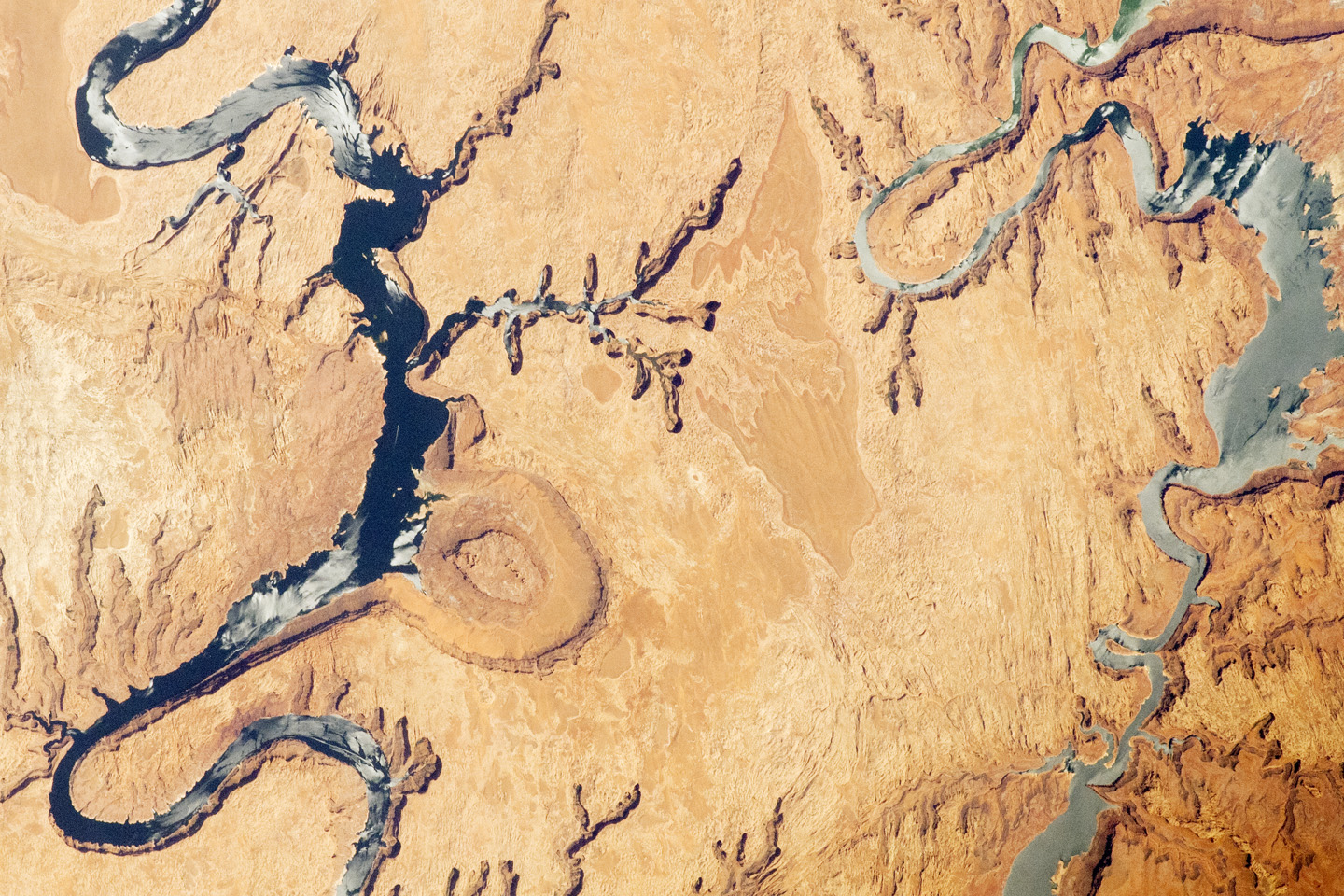
This astronaut photograph highlights part of Lake Powell, which extends across southeastern Utah and northeastern Arizona. Lake Powell started filling in 1963 when the Glen Canyon Dam was completed along the Colorado River in Arizona, and the canyon was flooded. The serpentine surface of the reservoir—highlighted by gray regions of sunglint—follows the incised course of the canyon, which was cut downwards into the existing rock layers by the erosive power of the river. The two branches shown in the image are connected by a bend to the southwest (not shown). Lake Powell is part of the Glen Canyon National Recreation Area, which extends for more than 300 kilometers (186 miles) along the shoreline and side canyons. The primary intended use of Lake Powell’s water is support for agriculture, with a small portion allocated to urban use in Arizona, Nevada, and California. The reservoir did not reach its maximum capacity of 27 million acre-feet until 1980. More recently, extended drought conditions in the southwestern United States have resulted in a significant lowering of the lake water level and the emergence of formerly submerged parts of Glen Canyon. Should average precipitation in the Colorado River watershed decrease (as predicted by regional climate change models), that could result in further lowering of Lake Powell and changes to the water management plans. Fluctuations in water levels and changes in river courses are a common occurrence in the geologic record of rivers. Looking somewhat like a donut or automobile tire from the vantage point of the International Space Station, The Rincon (image center) is an entrenched and abandoned meander, or loop, of the Colorado River. Scientists believe it formed several thousand years ago when the river cut straight across the ends of the loop and shortened its course by six miles. The resulting canyon and 600 to 750 feet-high central mesa indicate where the river used to flow. The term “rincon” also is used by geomorphologists to describe similar ancient river features observed elsewhere. The Goosenecks of the San Juan River are an example of an active entrenched meander. Astronaut photograph ISS031-E-6398 was acquired on April 30, 2012, with a Nikon D2Xs digital camera using a 400 mm lens, and is provided by the ISS Crew Earth Observations experiment and Image Science & Analysis Laboratory, Johnson Space Center. The image was taken by the Expedition 31 crew. It has been cropped and enhanced to improve contrast, and lens artifacts have been removed. The International Space Station Program supports the laboratory as part of the ISS National Lab to help astronauts take pictures of Earth that will be of the greatest value to scientists and the public, and to make those images freely available on the Internet. Additional images taken by astronauts and cosmonauts can be viewed at the NASA/JSC Gateway to Astronaut Photography of Earth. Caption by William L. Stefanov, Jacobs/ESCG at NASA-JSC. The Earth Observatory's mission is to share with the public the images, stories, and discoveries about climate and the environment that emerge from NASA research, including its satellite missions, in-the-field research, and climate models. Like us on Facebook Follow us on Twitter Add us to your circles on Google+ |
| Data | |
| Fonte | Lake Powell and The Rincon, Utah |
| Autore | NASA's Earth Observatory |
| Luogo dello scatto | | Posizione di questa e altre immagini su: OpenStreetMap |
|---|
Licenza
- Tu sei libero:
- di condividere – di copiare, distribuire e trasmettere quest'opera
- di modificare – di adattare l'opera
- Alle seguenti condizioni:
- attribuzione – Devi fornire i crediti appropriati, un collegamento alla licenza e indicare se sono state apportate modifiche. Puoi farlo in qualsiasi modo ragionevole, ma non in alcun modo che suggerisca che il licenziante approvi te o il tuo uso.
| Questa immagine è stata originariamente caricata su Flickr da NASA Earth Observatory all'indirizzo https://www.flickr.com/photos/68824346@N02/7242439920. È stata controllata in data 2 luglio 2012 dal robot FlickreviewR ed è stato confermato il suo rilascio sotto i termini della licenza cc-by-2.0. |
Cronologia del file
Fare clic su un gruppo data/ora per vedere il file come si presentava nel momento indicato.
| Data/Ora | Miniatura | Dimensioni | Utente | Commento | |
|---|---|---|---|---|---|
| attuale | 20:25, 11 mar 2021 | | 1 440 × 960 (1,53 MB) | Ulrichstill | full resolution and color slightly chanched |
| 19:02, 2 lug 2012 |  | 720 × 480 (179 KB) | Dzlinker | == {{int:filedesc}} == {{Information |Description=To download the full resolution and other files go to: [http://earthobservatory.nasa.gov/IOTD/view.php?id=77981&src=flickr earthobservatory.nasa.gov/IOTD/view.php?id=77981&src=...] This astronaut photo... |
Pagine che usano questo file
La seguente pagina usa questo file:
Utilizzo globale del file
Anche i seguenti wiki usano questo file:
- Usato nelle seguenti pagine di en.wikipedia.org: