File:Jason-1 measurement system.gif
Vai alla navigazione
Vai alla ricerca
Non sono disponibili versioni a risoluzione più elevata.
Jason-1_measurement_system.gif (651 × 527 pixel, dimensione del file: 72 KB, tipo MIME: image/gif)
| Questo file e la sua pagina di descrizione (discussione · modifica) si trovano su Wikimedia Commons (?) |
Dettagli
| Descrizione |
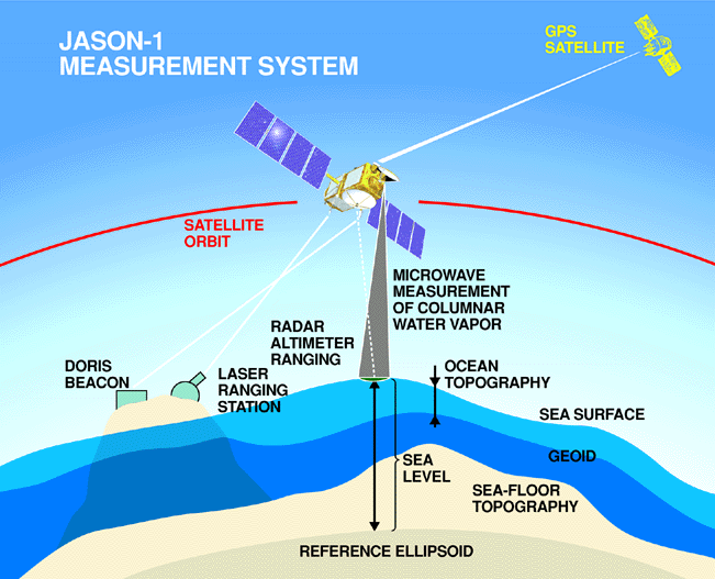
English: Every 10 days, Jason-1 measures the height of more than 90% of the world's ice-free ocean with its radar altimeter and completes 127 revolutions, or orbits, around Earth.
To measure sea surface height it is necessary to know satellite's exact position in its orbit and the distance between the satellite and the ocean's surface. Corrections are made for variable amounts of water vapor in the lower atmosphere and free electrons in the upper atmosphere, which can delay the altimeter's microwave pulses. The sea height caused by gravity (the geoid) is mathematically removed in order to create maps of ocean surface topography. |
| Data | |
| Fonte | http://sealevel.jpl.nasa.gov/gallery/posters.html |
| Autore | NASA/JPL |
Licenza
| Questo file è nel pubblico dominio perché creato dalla NASA. La politica sul copyright della NASA afferma che «il materiale della NASA non è protetto da copyright a meno che non sia specificato altrimenti». (NASA copyright policy e JPL Image Use Policy). | ||
 |
Attenzione:
|
Cronologia del file
Fare clic su un gruppo data/ora per vedere il file come si presentava nel momento indicato.
| Data/Ora | Miniatura | Dimensioni | Utente | Commento | |
|---|---|---|---|---|---|
| attuale | 20:39, 6 ott 2008 | | 651 × 527 (72 KB) | Maddox1 | {{Information |Description={{en|1=Every 10 days, Jason-1 measures the height of more than 90% of the world's ice-free ocean with its radar altimeter and completes 127 revolutions, or orbits, around Earth. To measure sea surface height it is necessary to |
Pagine che usano questo file
Le seguenti 2 pagine usano questo file:
Utilizzo globale del file
Anche i seguenti wiki usano questo file:
- Usato nelle seguenti pagine di ar.wikipedia.org:
- Usato nelle seguenti pagine di en.wikipedia.org:
- Usato nelle seguenti pagine di id.wikipedia.org:
- Usato nelle seguenti pagine di pt.wikipedia.org:
- Usato nelle seguenti pagine di ru.wikipedia.org:
- Usato nelle seguenti pagine di sr.wikipedia.org:
- Usato nelle seguenti pagine di uk.wikipedia.org: