File:Hurricane Emily 16 july 2005 1545Z.jpg
Vai alla navigazione
Vai alla ricerca

Dimensioni di questa anteprima: 466 × 599 pixel. Altre risoluzioni: 187 × 240 pixel | 373 × 480 pixel | 597 × 768 pixel | 796 × 1 024 pixel | 1 593 × 2 048 pixel | 5 600 × 7 200 pixel.
File originale (5 600 × 7 200 pixel, dimensione del file: 6,25 MB, tipo MIME: image/jpeg)
| Questo file e la sua pagina di descrizione (discussione · modifica) si trovano su Wikimedia Commons (?) |
Dettagli
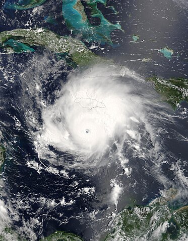
| Descrizione |
Hurricane Emily was spinning through the Caribbean south of Jamacia on July 16, 2005, when the Moderate Resolution Imaging Spectroradiometer (MODIS) on the Terra satellite captured this image at 15:45 UTC (11:45 a.m. Eastern Daylight Time). At this time, Emily was a well-developed hurricane with winds over 230 kilometers an hour (125 knots) and gusts as high as 285 km/hr (155 knots). As shown in this satellite image, the storm is passing roughly east to west well south of Jamaica (around 160 kilometers, or 100 miles), but the heavy rains in the storm's outer bands fell on an already sodden island still recovering from Hurricane Dennis, which similarly glanced the island on July 7. Emily's rains caused flooding, which has resulted in four deaths on the island. Tourists in the Yucatan Peninsula are being evacuated from resort areas and beaches as the hurricane continues on track to make landfall there during the morning of July 18, 2005. |
|||||
| Data | ||||||
| Fonte | http://earthobservatory.nasa.gov/NaturalHazards/natural_hazards_v2.php3?img_id=12967 | |||||
| Autore | NASA image provided courtesy of Jeff Schmaltz, MODIS Rapid Response team. | |||||
| Licenza (Riusare questo file) |
|
|||||
| Altre versioni | Image:Hurricane Emily.jpg |

Cronologia del file
Fare clic su un gruppo data/ora per vedere il file come si presentava nel momento indicato.
| Data/Ora | Miniatura | Dimensioni | Utente | Commento | |
|---|---|---|---|---|---|
| attuale | 11:44, 31 lug 2023 | | 5 600 × 7 200 (6,25 MB) | Nino Marakot | Reverted to version as of 06:40, 23 July 2018 (UTC) |
| 00:56, 7 dic 2018 |  | 6 401 × 8 401 (9,55 MB) | FleurDeOdile | actual center | |
| 08:40, 23 lug 2018 |  | 5 600 × 7 200 (6,25 MB) | Nino Marakot | Reverted to version as of 21:47, 2 November 2006 (UTC) | |
| 17:43, 22 apr 2018 |  | 1 540 × 1 900 (676 KB) | CooperScience | Larger file, centered, better quality | |
| 11:04, 24 mag 2017 |  | 466 × 599 (84 KB) | A1Cafel | clearer | |
| 23:47, 2 nov 2006 |  | 5 600 × 7 200 (6,25 MB) | Good kitty | == Summary == {{Information |Description=Hurricane Emily was spinning through the Caribbean south of Jamacia on July 16, 2005, when the Moderate Resolution Imaging Spectroradiometer (MODIS) on the Terra satellite captured this image at 15:45 UTC (11:45 a. |
Pagine che usano questo file
La seguente pagina usa questo file:
Utilizzo globale del file
Anche i seguenti wiki usano questo file:
- Usato nelle seguenti pagine di ca.wikipedia.org:
- Usato nelle seguenti pagine di de.wikipedia.org:
- Usato nelle seguenti pagine di en.wikipedia.org:
- Usato nelle seguenti pagine di eo.wikipedia.org:
- Usato nelle seguenti pagine di es.wikipedia.org:
- Usato nelle seguenti pagine di eu.wikipedia.org:
- Usato nelle seguenti pagine di fi.wikipedia.org:
- Usato nelle seguenti pagine di fr.wikipedia.org:
- Usato nelle seguenti pagine di hu.wikipedia.org:
- Usato nelle seguenti pagine di pl.wikipedia.org:
- Usato nelle seguenti pagine di pt.wikipedia.org:
- Usato nelle seguenti pagine di ru.wikipedia.org:
- Usato nelle seguenti pagine di simple.wikipedia.org:
- Usato nelle seguenti pagine di sv.wikipedia.org:
- Usato nelle seguenti pagine di uk.wikipedia.org:
- Usato nelle seguenti pagine di vi.wikipedia.org:
- Usato nelle seguenti pagine di www.wikidata.org:
- Usato nelle seguenti pagine di zh.wikipedia.org: