File:HampshireEast.png
Vai alla navigazione
Vai alla ricerca
Non sono disponibili versioni a risoluzione più elevata.
HampshireEast.png (200 × 178 pixel, dimensione del file: 15 KB, tipo MIME: image/png)
| Questo file e la sua pagina di descrizione (discussione · modifica) si trovano su Wikimedia Commons (?) |
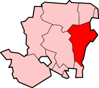
Hampshire East
Created by en:User:Morwen

|
È permesso copiare, distribuire e/o modificare questo documento in base ai termini della GNU Free Documentation License, Versione 1.2 o successive pubblicata dalla Free Software Foundation; senza alcuna sezione non modificabile, senza testo di copertina e senza testo di quarta di copertina. Una copia della licenza è inclusa nella sezione intitolata Testo della GNU Free Documentation License. |
| Questo file è disponibile in base alla licenza Creative Commons Attribuzione-Condividi allo stesso modo 3.0 Unported | ||
| ||
| Questo tag di copyright è stato aggiunto nell'ambito dell'aggiornamento della licenza dei progetti Wikimedia. |
Cronologia del file
Fare clic su un gruppo data/ora per vedere il file come si presentava nel momento indicato.
| Data/Ora | Miniatura | Dimensioni | Utente | Commento | |
|---|---|---|---|---|---|
| attuale | 21:26, 25 ago 2005 | | 200 × 178 (15 KB) | Cnyborg | From en:Image:HampshireEast.png by en:User:Morwen {{GFDL-en}} Category:Maps of English districts |
Pagine che usano questo file
La seguente pagina usa questo file:
Utilizzo globale del file
Anche i seguenti wiki usano questo file:
- Usato nelle seguenti pagine di de.wikipedia.org:
- Usato nelle seguenti pagine di en.wikipedia.org:
- Lovedean
- Alton, Hampshire
- Chawton
- East Hampshire
- Liphook
- Ropley
- Petersfield
- Selborne
- Holybourne
- Bordon
- Horndean
- East Meon
- Rowland's Castle
- Headley, East Hampshire
- Bentley, Hampshire
- Liss, Hampshire
- Lasham
- Four Marks
- Beech, Hampshire
- Bentworth
- Clanfield, Hampshire
- Binsted
- Newton Valence
- Buriton
- Froyle
- Greatham, Hampshire
- Grayshott
- Catherington
- Chalton, Hampshire
- Blendworth
- Finchdean
- Farringdon, Hampshire
- Sleaford, Hampshire
- Bramshott
- West Tisted
- Hill Brow
- East Tisted
- Lindford, Hampshire
- Arford
- Oakhanger, Hampshire
- Oakshott
- Langrish
- Privett
- Steep, Hampshire
- Conford
- Shalden
- Medstead
- Hawkley
- Template:East Hampshire
Visualizza l'utilizzo globale di questo file.