File:Erebus 360 L257atc-B652R1.jpg
Vai alla navigazione
Vai alla ricerca

Dimensioni di questa anteprima: 800 × 211 pixel. Altre risoluzioni: 320 × 84 pixel | 640 × 168 pixel | 1 024 × 270 pixel | 1 280 × 337 pixel | 2 560 × 674 pixel | 22 780 × 5 996 pixel.
File originale (22 780 × 5 996 pixel, dimensione del file: 74,36 MB, tipo MIME: image/jpeg)
| Questo file e la sua pagina di descrizione (discussione · modifica) si trovano su Wikimedia Commons (?) |
| Attenzione | Alcuni browser potrebbero avere dei problemi nel mostrare questa immagine a piena risoluzione: questa immagine è composta da un numero insolitamente alto di pixel e potrebbe non essere visualizzata correttamente o causare l'arresto del browser. |
|---|
Dettagli
| Descrizione |
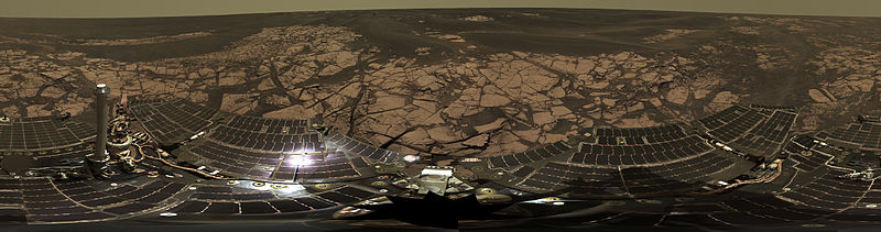
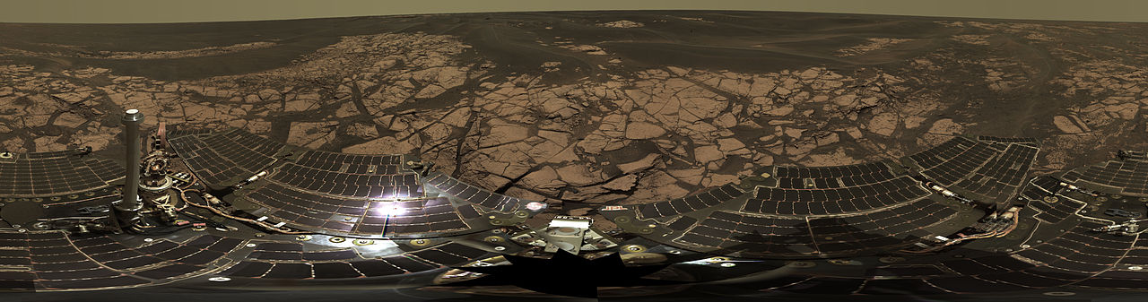
English: This is the Opportunity panoramic camera's "Erebus Rim" panorama, acquired on sols 652 to 663 (Nov. 23 to Dec. 5, 2005 ), as NASA's Mars Exploration Rover Opportunity was exploring sand dunes and outcrop rocks in Meridiani Planum. The panorama originally consisted of 635 separate images in four different Pancam filters, and covers 360 degrees of terrain around the rover and the full rover deck. Since the time that this panorama was acquired, and while engineers have been diagnosing and testing Opportunity's robotic arm, the panorama has been expanded to include more than 1,300 images of this terrain through all of the Pancam multispectral filters. It is the largest panorama acquired by either rover during the mission.
The panorama shown here is an approximate true-color rendering using Pancam's 750 nanometer, 530 nanometer and 430 nanometer filters. It is presented here as a cylindrical projection. Image-to-image seams have been eliminated from the sky portion of the mosaic to better simulate the vista a person standing on Mars would see. This panorama provides the team's highest resolution view yet of the finely-layered outcrop rocks, wind ripples, and small cobbles and grains along the rim of the wide but shallow "Erebus" crater. Once the arm diagnostics and testing are completed, the team hopes to explore other layered outcrop rocks at Erebus and then eventually continue southward toward the large crater known as "Victoria." |
| Data | tra il 23 novembre 2005 e il 5 dicembre 2005 |
| Fonte | http://marsrovers.jpl.nasa.gov/gallery/press/opportunity/20060104a.html / http://photojournal.jpl.nasa.gov/catalog/PIA03270 |
| Autore | NASA/JPL-Caltech/Cornell |
| 360° | Visualizza l'immagine panoramica a 360°
|
|---|
Questa immagine o filmato è stato catalogato dal Jet Propulsion Lab della National Aeronautics and Space Administration (NASA) degli Stati Uniti d'Americacon il Photo ID: PIA03270.Questo tag non indica lo status del copyright dell'opera ad esso associato. È quindi richiesto un normale tag di copyright. Vedi Commons:Licenze per maggiori informazioni. Altre lingue:
|
Licenza
| Questo file è nel pubblico dominio perché creato dalla NASA. La politica sul copyright della NASA afferma che «il materiale della NASA non è protetto da copyright a meno che non sia specificato altrimenti». (NASA copyright policy e JPL Image Use Policy). | ||
 |
Attenzione:
|
Cronologia del file
Fare clic su un gruppo data/ora per vedere il file come si presentava nel momento indicato.
| Data/Ora | Miniatura | Dimensioni | Utente | Commento | |
|---|---|---|---|---|---|
| attuale | 08:00, 22 feb 2013 | 22 780 × 5 996 (74,36 MB) | Huntster | Original super-resolution version of image. | |
| 12:50, 15 gen 2006 | 3 000 × 790 (523 KB) | JamesHoadley | w:Erebus crater. From [http://marsrovers.jpl.nasa.gov/gallery/press/opportunity/20060104a.html]. Original caption: <blockquote>'''On the Rim of 'Erebus'''' This is the Opportunity panoramic camera's "Erebus Rim" panorama, acquired on sols 652 to 66 |
Pagine che usano questo file
La seguente pagina usa questo file:
Utilizzo globale del file
Anche i seguenti wiki usano questo file:
- Usato nelle seguenti pagine di ast.wikipedia.org:
- Usato nelle seguenti pagine di bs.wikipedia.org:
- Usato nelle seguenti pagine di de.wikipedia.org:
- Usato nelle seguenti pagine di en.wikipedia.org:
- Usato nelle seguenti pagine di es.wikipedia.org:
- Usato nelle seguenti pagine di fr.wikipedia.org:
- Usato nelle seguenti pagine di hi.wikipedia.org:
- Usato nelle seguenti pagine di ja.wikipedia.org:
- Usato nelle seguenti pagine di ko.wikipedia.org:
- Usato nelle seguenti pagine di lb.wikipedia.org:
- Usato nelle seguenti pagine di mn.wikipedia.org:
- Usato nelle seguenti pagine di pt.wikipedia.org:
- Usato nelle seguenti pagine di ro.wikipedia.org:
- Usato nelle seguenti pagine di ru.wikipedia.org:
- Usato nelle seguenti pagine di uk.wikipedia.org:
- Usato nelle seguenti pagine di zh.wikipedia.org: