File:DESERTEC-Map large.jpg

File originale (5 776 × 4 184 pixel, dimensione del file: 8,61 MB, tipo MIME: image/jpeg)
| Questo file e la sua pagina di descrizione (discussione · modifica) si trovano su Wikimedia Commons (?) |

|
Questa immagine (categorizzazione automatica: map) o tutte le immagini in questa categoria o galleria dovrebbero essere ricreate usando grafica vettoriale come file SVG. Questo offre diversi vantaggi: vedi Commons:Media for cleanup per maggiori informazioni. Se è disponibile una versione in formato SVG di questa immagine, per favore caricala. Dopo aver caricato un file SVG, sostituisci questo avviso con il template {{Vector version available|nome_immagine.svg}}.
|


| Descrizione |
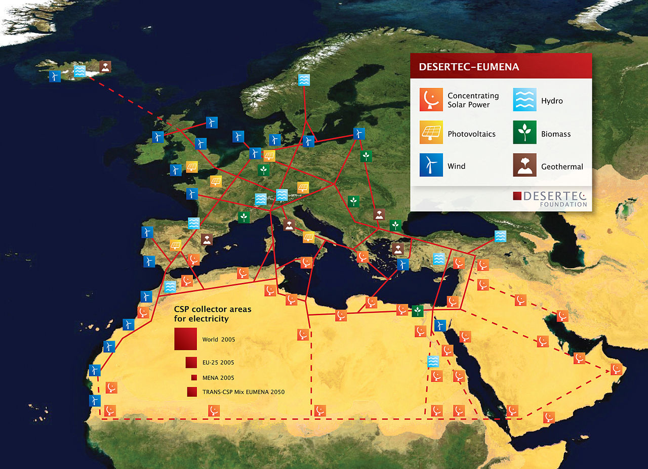
English: DESERTEC EU-MENA Map: Sketch of possible infrastructure for a sustainable supply of power to Europe, the Middle East and North Africa (EU-MENA) proposed by TREC)
For illustration: The red squares represent the total surfaces needed for solar collectors of Concentrating Solar Thermal Power (CSP) plants to provide the present electricity demands - for the world (18.000 TWh/a, 300x300 km) - for Europe (EU 3.200 TWh/a, 125x125 km) - and for Germany or MENA (Middle East and North Africa, about 600 TWh/a, 55x55 km). - The square labeled "TRANS-CSP Mix EUMENA 2050" indicates the surface needed for solar collectors to realize DESERTEC in EU-MENA (according to the TRANS-CSP scenario by DLR). This way the needs for seawater desalination and about two-thirds of the rising electricity consumption in the MENA region could be provided and about 17 percent of the European electricity consumption in 2050 (2,940 TWh/a, 120x120 km² in total). In reality numerous CSP-Plants will be spread in the deserts of EU-MENA and around the globe.
Deutsch: DESERTEC EU-MENA Karte: Skizze einer möglichen Infrastruktur für eine nachhaltige Stromversorgung in Europa, dem Nahen Osten und Nord-Afrika (EU-MENA).
Zur Veranschaulichung: Die durch die roten Quadrate markierten Flächen für Solarkollektoren würden genügen, um in solarthermischen Kraftwerken (CSP) den Strombedarf - der Welt (18.000 TWh/a, 300x300 km), - Europas (EU, 3.200 TWh/a, 125x125 km) - und von Deutschland bzw. MENA (Middle East and North Africa, ca. 600 TWh/a, 55x55 km) zu erzeugen. - Das Quadrat "TRANS-CSP Mix EUMENA 2050" zeigt die insgesamt benötigte Fläche für Solarkollektoren, um DESERTEC in EU-MENA zu realisieren (entsprechend dem TRANS-CSP Szenario des DLR). Auf diese Weise könnte genügend Energie erzeugt werden, um den Bedarf an Meerwasserentsalzung und zwei Drittel des bis 2050 stark wachsenden Strombedarfs der MENA-Region zu decken sowie etwa 17 Prozent des europäischen Strombedarfs (zusammen 2,940 TWh/a, 120x120 km). In der Realität werden viele CSP-Kraftwerke über die Wüsten der MENA-Region und der Welt verteilt sein. Die gestrichelten Linien stellen eine zweite Ausbaustufe dar. |
| Data | |
| Fonte | http://www.desertec.org/fileadmin/downloads/press/DESERTEC-Map.zip |
| Autore | DESERTEC Foundation, www.desertec.org |
| Licenza (Riusare questo file) |
Questo file è disponibile in base alla licenza Creative Commons Attribuzione-Condividi allo stesso modo 2.5 Generico
|
| Altre versioni |
|

Cronologia del file
Fare clic su un gruppo data/ora per vedere il file come si presentava nel momento indicato.
| Data/Ora | Miniatura | Dimensioni | Utente | Commento | |
|---|---|---|---|---|---|
| attuale | 21:40, 7 feb 2011 | | 5 776 × 4 184 (8,61 MB) | Benderson2~commonswiki | Udated version http://www.desertec.org/en/press/ without symols in the Western Sahara conflict region. |
| 19:39, 5 mar 2009 |  | 5 777 × 4 185 (8,09 MB) | Chstdu | {{Information |Description={{en|1=Sketch of possible infrastructure for a sustainable supply of power to EUrope, the Middle East and North Africa (EU-MENA) (Euro-Supergrid with a EU-MENA-Connection proposed by [[w:Trans-Mediterranean_Renewable_Energy_Coop |
Pagine che usano questo file
Le seguenti 2 pagine usano questo file:
Utilizzo globale del file
Anche i seguenti wiki usano questo file:
- Usato nelle seguenti pagine di ar.wikipedia.org:
- Usato nelle seguenti pagine di ca.wikipedia.org:
- Usato nelle seguenti pagine di ckb.wikipedia.org:
- Usato nelle seguenti pagine di cs.wikipedia.org:
- Usato nelle seguenti pagine di de.wikipedia.org:
- Sonnenenergie
- Europäisches Verbundsystem
- Erneuerbare Energien
- Desertec
- Energiewende
- Diskussion:Desertec/Archiv/1
- Wikipedia Diskussion:Hauptseite/Artikel des Tages/Archiv/Vorschläge/2011/1
- Wikipedia Diskussion:Hauptseite/Artikel des Tages/Archiv/Vorschläge/2012/2
- Wikipedia:Hauptseite/Archiv/10. November 2012
- Usato nelle seguenti pagine di en.wikipedia.org:
- Usato nelle seguenti pagine di eo.wikipedia.org:
- Usato nelle seguenti pagine di es.wikipedia.org:
- Usato nelle seguenti pagine di fi.wikipedia.org:
- Usato nelle seguenti pagine di fr.wikipedia.org:
- Usato nelle seguenti pagine di fr.wikiversity.org:
- Usato nelle seguenti pagine di hr.wikipedia.org:
- Usato nelle seguenti pagine di hu.wikipedia.org:
- Usato nelle seguenti pagine di ja.wikipedia.org:
- Usato nelle seguenti pagine di pt.wikipedia.org:
- Usato nelle seguenti pagine di ru.wikipedia.org:
- Usato nelle seguenti pagine di shi.wikipedia.org:
- Usato nelle seguenti pagine di sh.wikipedia.org:
- Usato nelle seguenti pagine di sv.wikipedia.org:
- Usato nelle seguenti pagine di uk.wikipedia.org:
- Usato nelle seguenti pagine di vi.wikipedia.org:
- Usato nelle seguenti pagine di www.wikidata.org:
- Usato nelle seguenti pagine di zh.wikipedia.org: