File:Civitatis imp Lindaviensis territorivm.jpg
Vai alla navigazione
Vai alla ricerca

Dimensioni di questa anteprima: 752 × 599 pixel. Altre risoluzioni: 301 × 240 pixel | 602 × 480 pixel | 964 × 768 pixel | 1 280 × 1 020 pixel | 2 560 × 2 041 pixel | 5 500 × 4 384 pixel.
File originale (5 500 × 4 384 pixel, dimensione del file: 2,37 MB, tipo MIME: image/jpeg)
| Questo file e la sua pagina di descrizione (discussione · modifica) si trovano su Wikimedia Commons (?) |
| Descrizione |
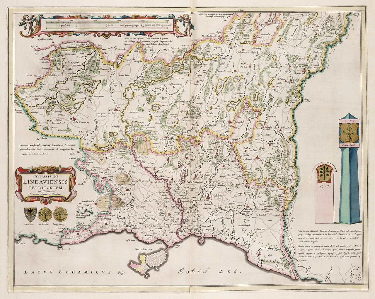
Deutsch: CIVITATIS IMP. LINDAVIENSIS TERRITORIVM. ita Delineabat Iohannes Andreas Rauhen, Amsterdam 1663 (Das Gebiet der Reichsstadt Lindau) |
| Data | |
| Fonte |
David Rumsey map collection https://resolver.kb.nl/resolve?urn=urn:gvn:NESA01:L02-0850 English: Map published in 1665 by Amsterdam geographer and map publisher Johannes Blaeu showing the territory of the Free Imperial City of Lindau ("Civitatis Imp. Lindaviensis Territorivm") on the shores of Lake Constance. The town of Lindau proper is located on the small offhore island at the bottom of the map. Politically, Lindau also ruled over a territory on the mainland. In the area bordered in pink, Lindau exercised full sovereignty, while in the area to the north, bordered in yellow, it shared sovereignty with the neighbouring counts of Monfort-Tettnang who exercised high jurisdiction (Hochgerichtsbarkeit), while Lindau exercised low jurisdiction (Niedergericht). A complementary map showing the northernmost tip of the territory not shown in the above map was also issued (see below). (Information taken from Werner Dobras, "Lindau, Reichsstadt" in: Historisches Lexikon Bayerns (04.10.2010). |
| Autore | Johannes Blaeu; Johannes Andreas Rauhen |
| Altre versioni |
|

|
Quest'opera è nel pubblico dominio anche in tutti i Paesi e nelle aree in cui la durata del copyright è la vita dell'autore più 100 anni o meno. | |
| Questo file è stato identificato come libero da restrizioni conosciute riguardanti le leggi sul copyright, compresi tutti i diritti connessi e vicini. | |
Cronologia del file
Fare clic su un gruppo data/ora per vedere il file come si presentava nel momento indicato.
| Data/Ora | Miniatura | Dimensioni | Utente | Commento | |
|---|---|---|---|---|---|
| attuale | 21:07, 13 gen 2010 | | 5 500 × 4 384 (2,37 MB) | AndreasPraefcke | {{Information |Description=CIVITATIS IMP. LINDAVIENSIS TERRITORIVM. ita Delineabat Iohannes Andreas Rauhen, Amsterdam 1663 (Das Gebiet der Reichsstadt Lindau) |Source=http://www.geheugenvannederland.nl/?/en/items/NESA01:L02-0850 |Date=1663 |Author= Johan |
Pagine che usano questo file
Le seguenti 2 pagine usano questo file: