File:British postcode areas map.svg
Vai alla navigazione
Vai alla ricerca

Dimensioni di questa anteprima PNG per questo file SVG: 388 × 600 pixel. Altre risoluzioni: 155 × 240 pixel | 310 × 480 pixel | 497 × 768 pixel | 663 × 1 024 pixel | 1 325 × 2 048 pixel | 886 × 1 369 pixel.
File originale (file in formato SVG, dimensioni nominali 886 × 1 369 pixel, dimensione del file: 846 KB)
| Questo file e la sua pagina di descrizione (discussione · modifica) si trovano su Wikimedia Commons (?) |
W3C-validity not checked.
Dettagli
| Luogo dello scatto | | Posizione di questa e altre immagini su: OpenStreetMap |
|---|
| Descrizione |
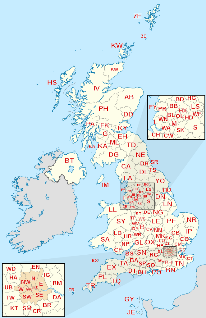
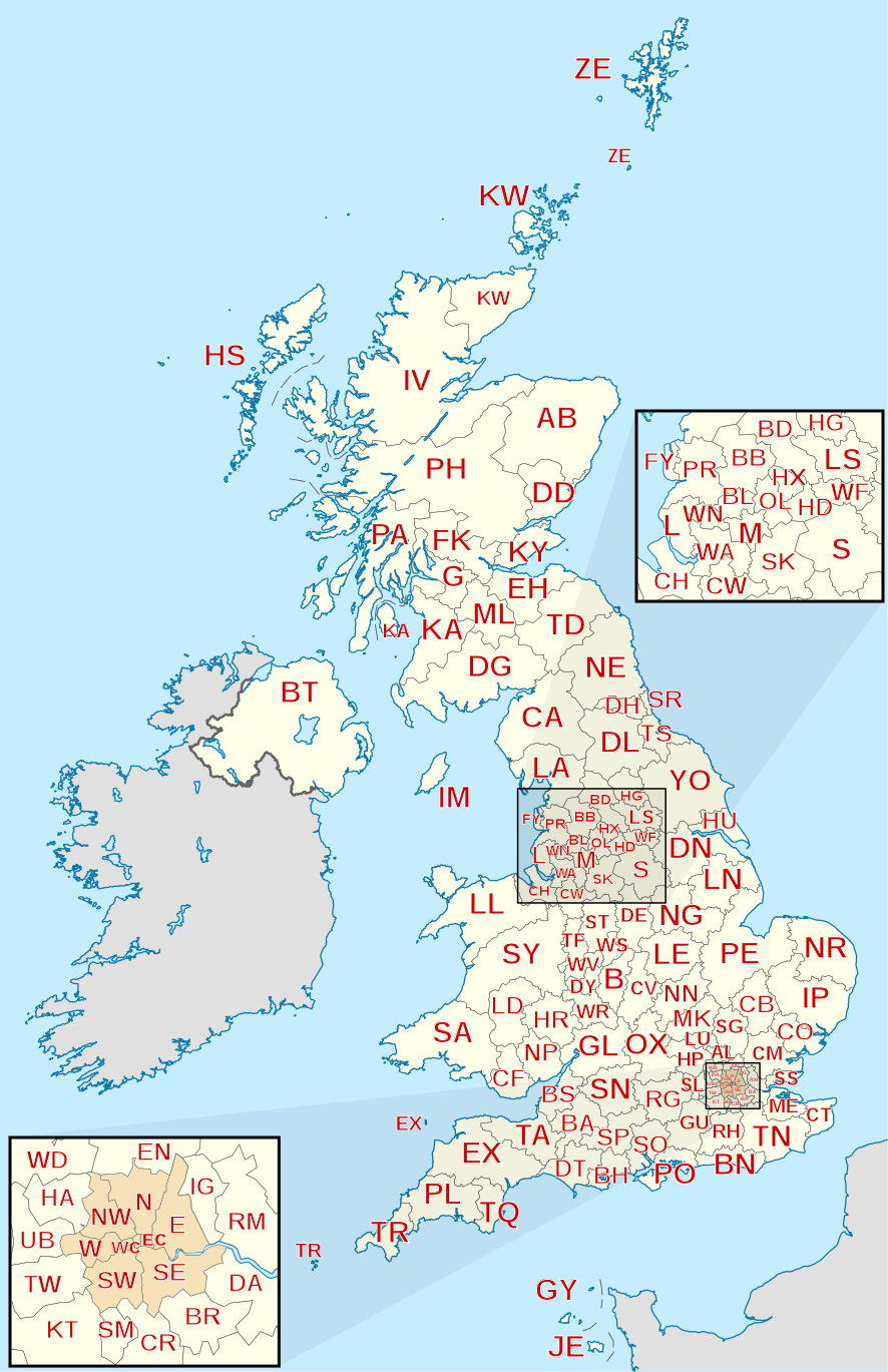
English: Labelled map of Royal Mail postcode areas of the United Kingdom and Crown Dependencies with insets for Manchester and London conurbations.
Equirectangular projection with latitude stretching 170%, WGS84 datum. Geographic limits:
|
| Data | |
| Fonte |
Derived from Ordnance Survey OS OpenData.
|
| Autore | Richardguk |
| Altre versioni |
|


Licenza
Io, detentore del copyright su quest'opera, dichiaro di pubblicarla con la seguente licenza:
Questo file è disponibile in base alla licenza Creative Commons Attribuzione-Condividi allo stesso modo 3.0 Unported
- Tu sei libero:
- di condividere – di copiare, distribuire e trasmettere quest'opera
- di modificare – di adattare l'opera
- Alle seguenti condizioni:
- attribuzione – Devi fornire i crediti appropriati, un collegamento alla licenza e indicare se sono state apportate modifiche. Puoi farlo in qualsiasi modo ragionevole, ma non in alcun modo che suggerisca che il licenziante approvi te o il tuo uso.
- condividi allo stesso modo – Se remixi, trasformi o sviluppi il materiale, devi distribuire i tuoi contributi in base alla stessa licenza o compatibile all'originale.
This file is licensed by the Ordnance Survey of the United Kingdom under their OS OpenData License
In short: you are free to distribute and modify the file as long as you attribute (including year), the Ordnance Survey and Royal Mail. Attribuzione: Contains Ordnance Survey and Royal Mail data © Crown copyright and database right (year) Note: Derivative works can be licensed under any Creative Commons Attribution 3.0 Licence. |
_(St_Edwards_Crown).svg)
|
This file is licensed under the United Kingdom Open Government Licence v3.0. |
See also: Meta for information on usage on Wikimedia wikis.
|
Questa immagine vettoriale include elementi che sono stati presi o adattati da questa:
Cronologia del file
Fare clic su un gruppo data/ora per vedere il file come si presentava nel momento indicato.
| Data/Ora | Miniatura | Dimensioni | Utente | Commento | |
|---|---|---|---|---|---|
| attuale | 07:45, 28 gen 2012 | | 886 × 1 369 (846 KB) | Richardguk | Clipped postcode area strokes to GB mainland (requires non-rectangular clip-path renderer); added dashed strokes to clarify nearby offshore postcode area boundaries (France–GY, France–JE, GY–JE, HS–IV, IV–PH, KA–PA, PA–PH); font-family="'Lib |
| 00:00, 2 dic 2011 |  | 886 × 1 369 (844 KB) | Richardguk | Main map limits and coastline taken from File:United Kingdom location map.svg. Label sizes refined. Colour-scheme amended for greater similarity with UK location maps. SVG out | |
| 18:19, 25 nov 2011 |  | 498 × 986 (368 KB) | Richardguk |
Pagine che usano questo file
La seguente pagina usa questo file:
Utilizzo globale del file
Anche i seguenti wiki usano questo file:
- Usato nelle seguenti pagine di cy.wikipedia.org:
- Usato nelle seguenti pagine di de.wikipedia.org:
- Usato nelle seguenti pagine di en.wikipedia.org:
- Usato nelle seguenti pagine di fr.wikipedia.org:
- Usato nelle seguenti pagine di gu.wikipedia.org:
- Usato nelle seguenti pagine di hi.wikipedia.org:
- Usato nelle seguenti pagine di kn.wikipedia.org:
- Usato nelle seguenti pagine di simple.wikipedia.org:
- Usato nelle seguenti pagine di ur.wikipedia.org: