File:Bazentin le Petit 14 July 1916 map.png

File originale (1 000 × 632 pixel, dimensione del file: 113 KB, tipo MIME: image/png)
| Questo file e la sua pagina di descrizione (discussione · modifica) si trovano su Wikimedia Commons (?) |
Dettagli
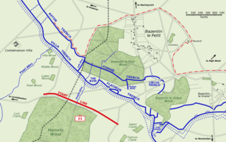
Map of Bazentin le Petit sector on the morning of 14 July 1916, Battle of Bazentin Ridge, showing the German second defensive position.
German trenches are shown in blue, including the communications trenches connecting to the (captured) first position. German barbed wire is shown as dotted blue lines. The start line of the assault brigades of the British 21st Division is shown in red. The position reached by the 21st Division and neighbouring 7th Division at 9 am is shown as the dashed red line.
Based on a trench map from the British Public Record Office.
| Quest'opera è stata rilasciata nel pubblico dominio dal suo autore, Gsl. Questa norma si applica in tutto il mondo. In alcuni paesi questo potrebbe non essere legalmente possibile. In tal caso: |
Cronologia del file
Fare clic su un gruppo data/ora per vedere il file come si presentava nel momento indicato.
| Data/Ora | Miniatura | Dimensioni | Utente | Commento | |
|---|---|---|---|---|---|
| attuale | 12:38, 21 ott 2005 | | 1 000 × 632 (113 KB) | Igiveup | Map of Bazentin le Petit sector on the morning of 14 July 1916, Battle of Bazentin Ridge, showing the German second defensive position. German trenches are shown in blue, including the communications trenches connecting to the (captured) first position. |
Pagine che usano questo file
Le seguenti 2 pagine usano questo file:
Utilizzo globale del file
Anche i seguenti wiki usano questo file:
- Usato nelle seguenti pagine di af.wikipedia.org:
- Usato nelle seguenti pagine di azb.wikipedia.org:
- Usato nelle seguenti pagine di ca.wikipedia.org:
- Usato nelle seguenti pagine di el.wikipedia.org:
- Usato nelle seguenti pagine di en.wikipedia.org:
- Usato nelle seguenti pagine di es.wikipedia.org:
- Usato nelle seguenti pagine di fr.wikipedia.org:
- Usato nelle seguenti pagine di hu.wikipedia.org:
- Usato nelle seguenti pagine di id.wikipedia.org:
- Usato nelle seguenti pagine di lt.wikipedia.org:
- Usato nelle seguenti pagine di no.wikipedia.org: