File:Airports in Norway map.svg
Vai alla navigazione
Vai alla ricerca

Dimensioni di questa anteprima PNG per questo file SVG: 501 × 526 pixel. Altre risoluzioni: 229 × 240 pixel | 457 × 480 pixel | 731 × 768 pixel | 975 × 1 024 pixel | 1 951 × 2 048 pixel.
File originale (file in formato SVG, dimensioni nominali 501 × 526 pixel, dimensione del file: 166 KB)
| Questo file e la sua pagina di descrizione (discussione · modifica) si trovano su Wikimedia Commons (?) |
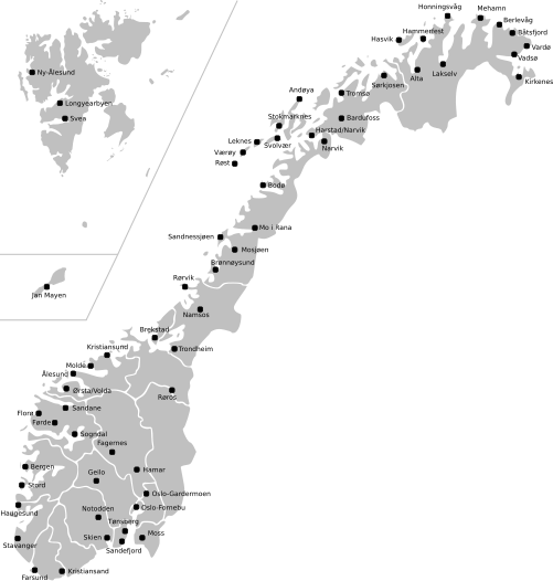
| Descrizione | Map of Norway with all current and former public and military airports. This excludes private airports without scheduled services. Note: Svalbard and Jan Mayen are not to scale, and not geographically correctly located in relation to each other and mainland Norway. The accuracy of the map makes accurate placement of the airports sometimes a little off. |
| Data | (UTC) |
| Fonte | |
| Autore |
|
Questo file è disponibile in base alla licenza Creative Commons Attribuzione-Condividi allo stesso modo 3.0 Unported
- Tu sei libero:
- di condividere – di copiare, distribuire e trasmettere quest'opera
- di modificare – di adattare l'opera
- Alle seguenti condizioni:
- attribuzione – Devi fornire i crediti appropriati, un collegamento alla licenza e indicare se sono state apportate modifiche. Puoi farlo in qualsiasi modo ragionevole, ma non in alcun modo che suggerisca che il licenziante approvi te o il tuo uso.
- condividi allo stesso modo – Se remixi, trasformi o sviluppi il materiale, devi distribuire i tuoi contributi in base alla stessa licenza o compatibile all'originale.
Registro originale del caricamento
This image is a derivative work of the following images:
- File:Norway_counties_blank.svg licensed with Cc-by-sa-2.5
- 2008-07-16T09:52:07Z ZorroIII 256x256 (84546 Bytes) Correct county code for Telemark
- 2007-09-21T21:39:11Z Marmelad 256x256 (84546 Bytes) added information about regions
- 2007-09-21T21:24:01Z Marmelad 256x256 (84348 Bytes) forgot to remove example colouring
- 2007-09-21T21:23:01Z Marmelad 256x256 (84340 Bytes) {{Information |Description=Blank map of Norwegian counties, used e.g. to create locator maps. |Source=Based on [[:Image:Norway counties.svg]] |Date=2007-09-21 |Author=[[User:Marmelad|Marmelad]] |Permission= {{cc-by-sa-2.5}}
- File:Svalbard_outline.svg licensed with PD-self
- 2009-04-28T10:05:31Z Arsenikk 200x265 (39847 Bytes) {{Information |Description={{en|1=Vector outline map of Svalbard, Norway.}} |Source=Own work by uploader |Author=[[User:Arsenikk|Arsenikk]] |Date=2009-04-29 |Permission= |other_versions= }} [[Category:Maps of Svalbard]] [[C
- File:Jan_Mayen_outline.svg licensed with PD-self
- 2009-09-12T10:29:46Z Arsenikk 294x267 (8401 Bytes) {{Information |Description=Blank map of Jan Mayen (Norway) |Source=*[[:File:Jan_Mayen_blank.jpg|]] |Date=2009-09-12 10:28 (UTC) |Author=*[[:File:Jan_Mayen_blank.jpg|]]: Alfanje *derivative work: ~~~ |Permission=see below |oth
Uploaded with derivativeFX
Cronologia del file
Fare clic su un gruppo data/ora per vedere il file come si presentava nel momento indicato.
| Data/Ora | Miniatura | Dimensioni | Utente | Commento | |
|---|---|---|---|---|---|
| attuale | 13:23, 2 mag 2021 | | 501 × 526 (166 KB) | BIL | I moved some airports slightly to reflect their actual position |
| 14:15, 12 set 2009 |  | 501 × 526 (170 KB) | Arsenikk | {{Information |Description=Map of Norway with all current and former public and military airports. This excludes private airports without scheduled services. Note: Svalbard and Jan Mayen are not to scale, and not geographically correctly located in relati |
Pagine che usano questo file
La seguente pagina usa questo file:
Utilizzo globale del file
Anche i seguenti wiki usano questo file:
- Usato nelle seguenti pagine di en.wikipedia.org:
- Usato nelle seguenti pagine di fa.wikipedia.org:
- Usato nelle seguenti pagine di fr.wikipedia.org:
- Usato nelle seguenti pagine di no.wikipedia.org:
- Usato nelle seguenti pagine di uk.wikipedia.org:
- Usato nelle seguenti pagine di zh.wikipedia.org: